
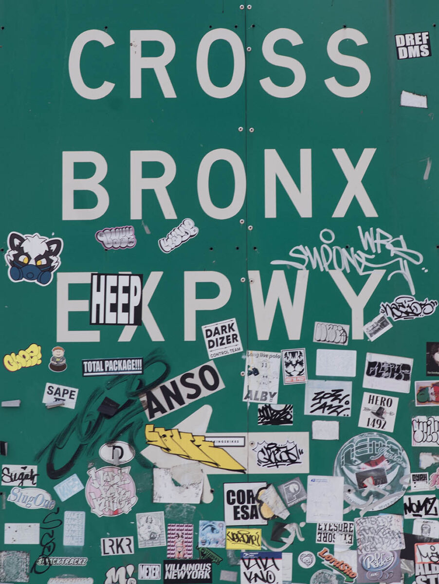
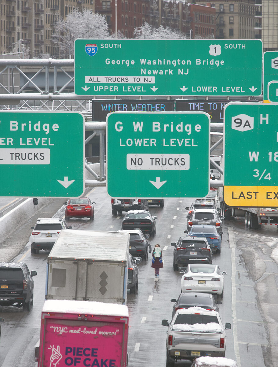
On Amsterdam Avenue in Manhattan, a sign directs traffic on to the Cross Bronx Expressway.
Back in 1947, long before political correctness or identity politics, residents protested the use of eminent domain to clear the route for I-95. The neighborhoods being erased were largely Jewish and working-class, with Italian and Irish families living door to door, all of the same social stripe. These were the first people here and got hit hardest. Anyone who has actually lived through forced displacement knows what that means, and anyone who hasn’t should tread carefully. Moses did not carve around the Jewish Bronx.
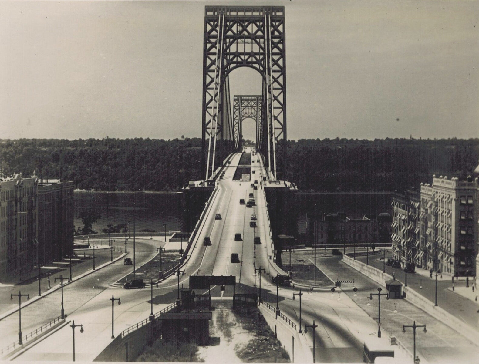
The light traffic is indicative of the era. A total of 6,148,876 vehicles crossed the bridge in 1934. Today over 114 million vehicles make the crossing.12 to 13 workers died during the construction of the George Washington Bridge between 1927 and 1931. No record-keeping on the Bronx trench. The bridge was built long before the interstate system. Does anybody really believe that in the city that invented capitalism itself wasn’t going to grow and redevelop further? Interstate 80 meets interstate 95 at the George Washington Bridge. There are multiple parks and another interstate that travel north and south through Manhattan and the Bronx.
The Cut cost 40 million increasing to 53 million soon, which is 500 million in today’s terms, actually a deal. Very recently, a Big Dig in Boston was completed. It was another transportation system, cutting directly through the city and the most expensive by far at 24 billion. But it had enormous benefits for Boston neighborhoods by easing congestion. A $24 billion price tag gives you an idea of what it would take to transform the Cross Bronx Expressway and the Manhattan trench into something similar to Boston. Can we spend $50 billion for the CBE in the face of just one other infrastructure project – the rehab rehabilitation of the New York system along with defensive measures against future flooding in hurricanes.
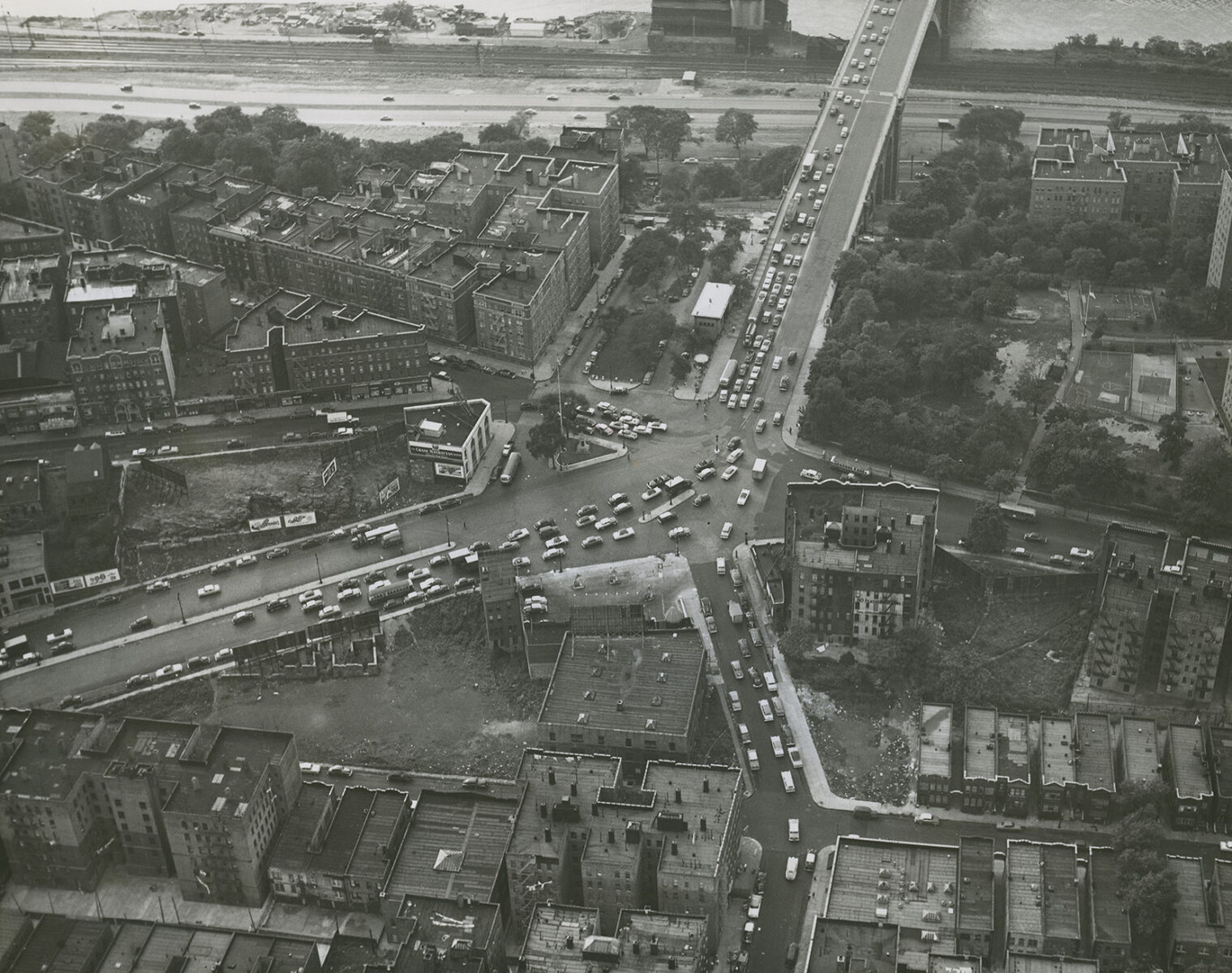
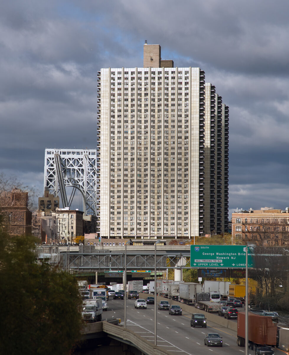
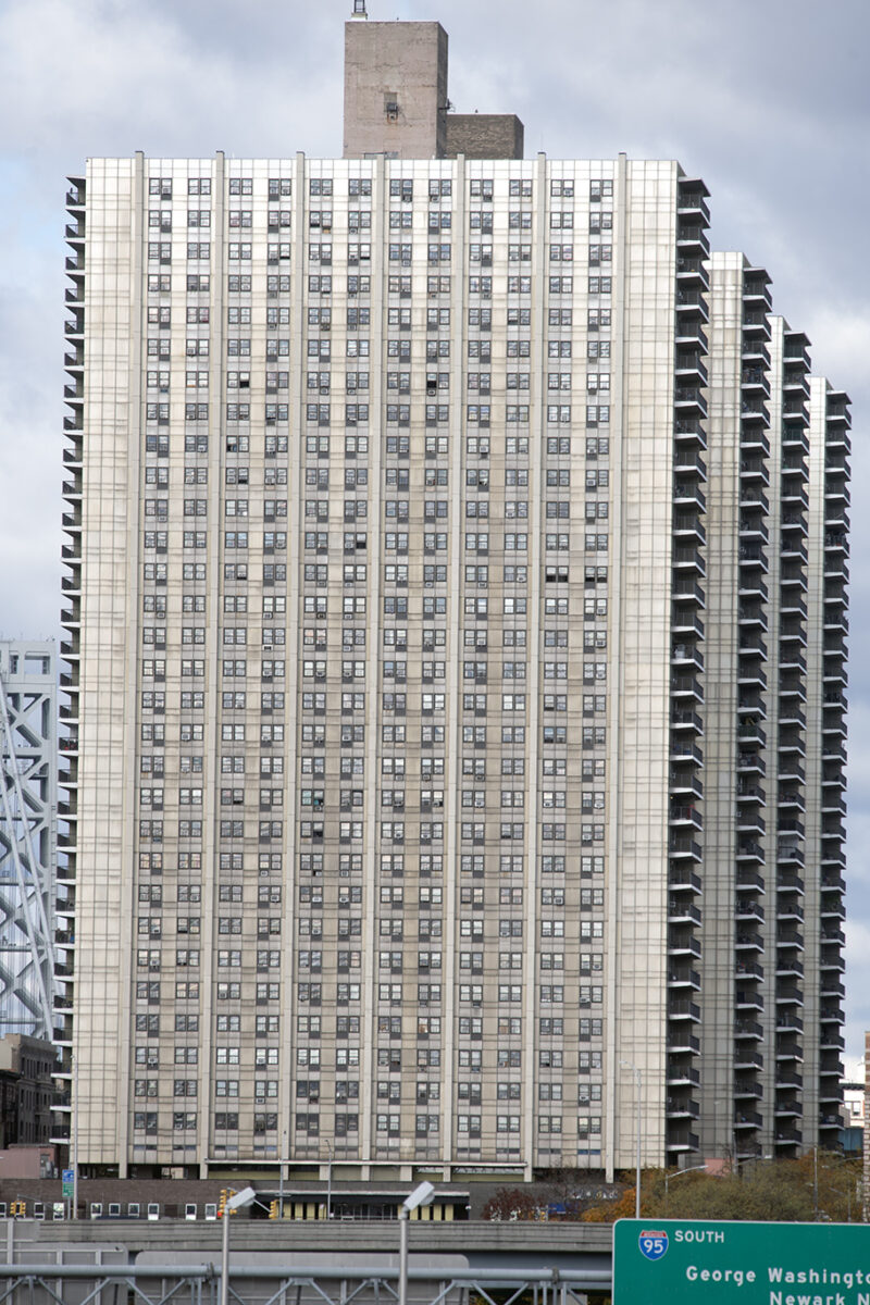
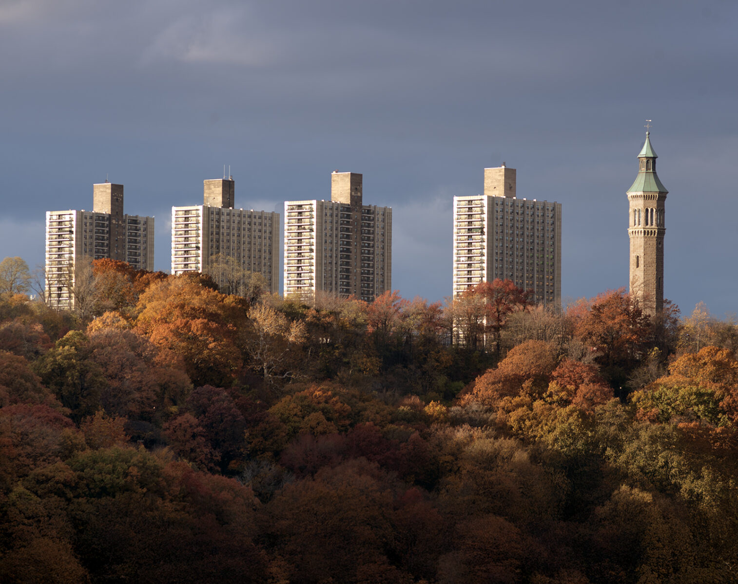
The George Washington Bridge had opened in 1931. By the 1940s, once the Trans-Manhattan Expressway was cut across upper Manhattan, you could drive in a straight engineered line from the Hudson River to the Harlem River without touching the old street grid in any meaningful way. In the age of leaded gas and no pollution controls on vehicles, Moses carved it out of Manhattan and the Bronx, and this was a huge problem, along with the look of it, that made folks avoid the area for many years. That ended and continues to be another booming area in Bronx real estate today, as you will see.
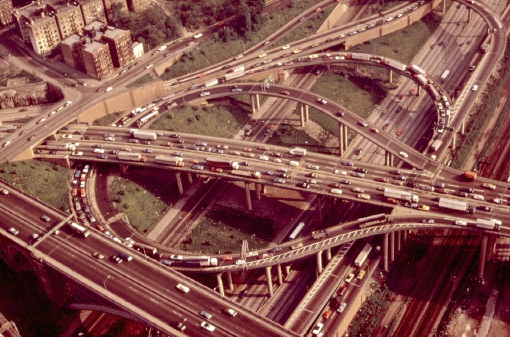
From there, the Cross Bronx extended the incision another six and a half miles to the Bruckner Interchange. Measure Interstate 95 from the Hudson River landing to the Bruckner and you get roughly nine to nine and a half miles of uninterrupted will.
Less than ten miles of roadway that people have tripped on literally and figuratively.
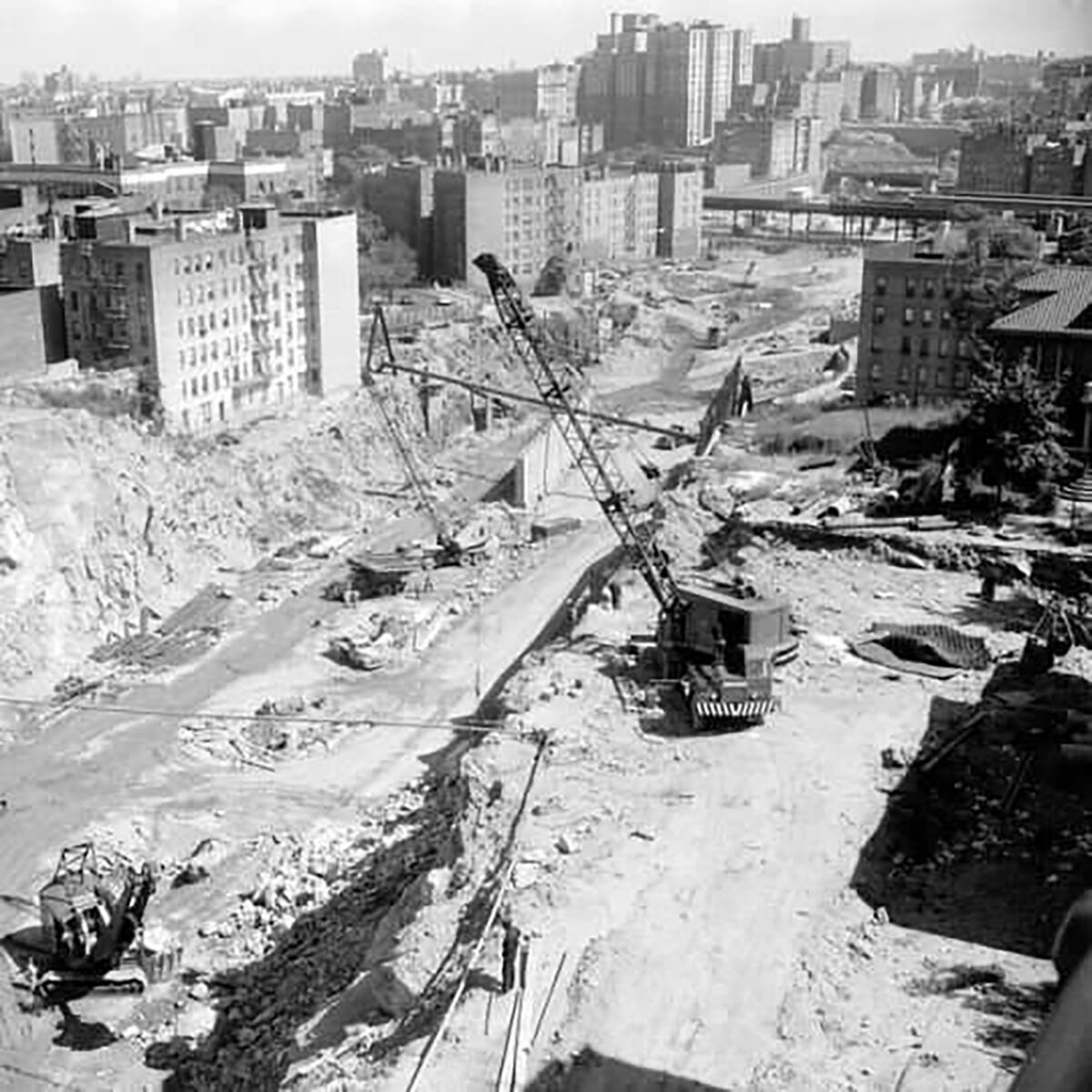
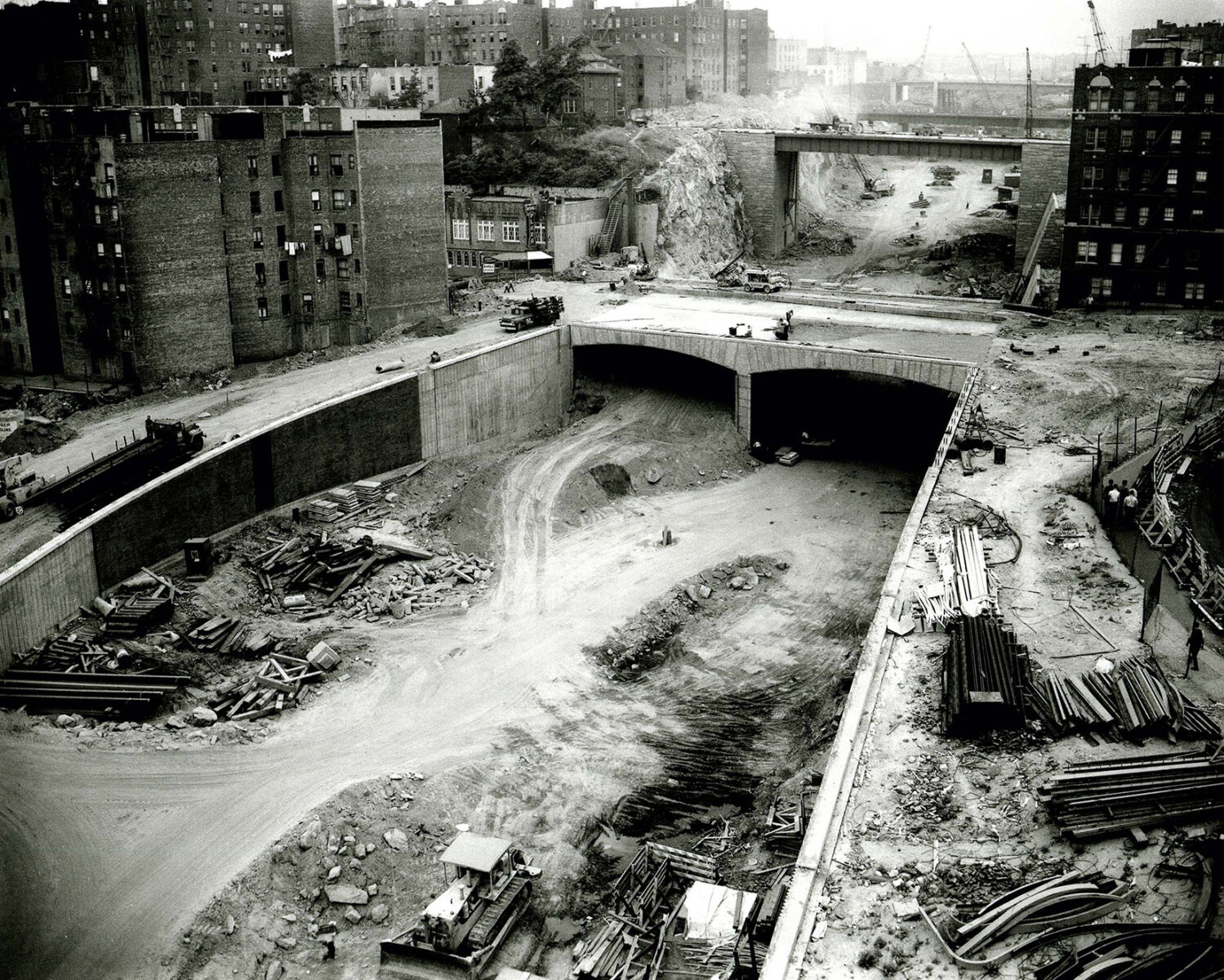
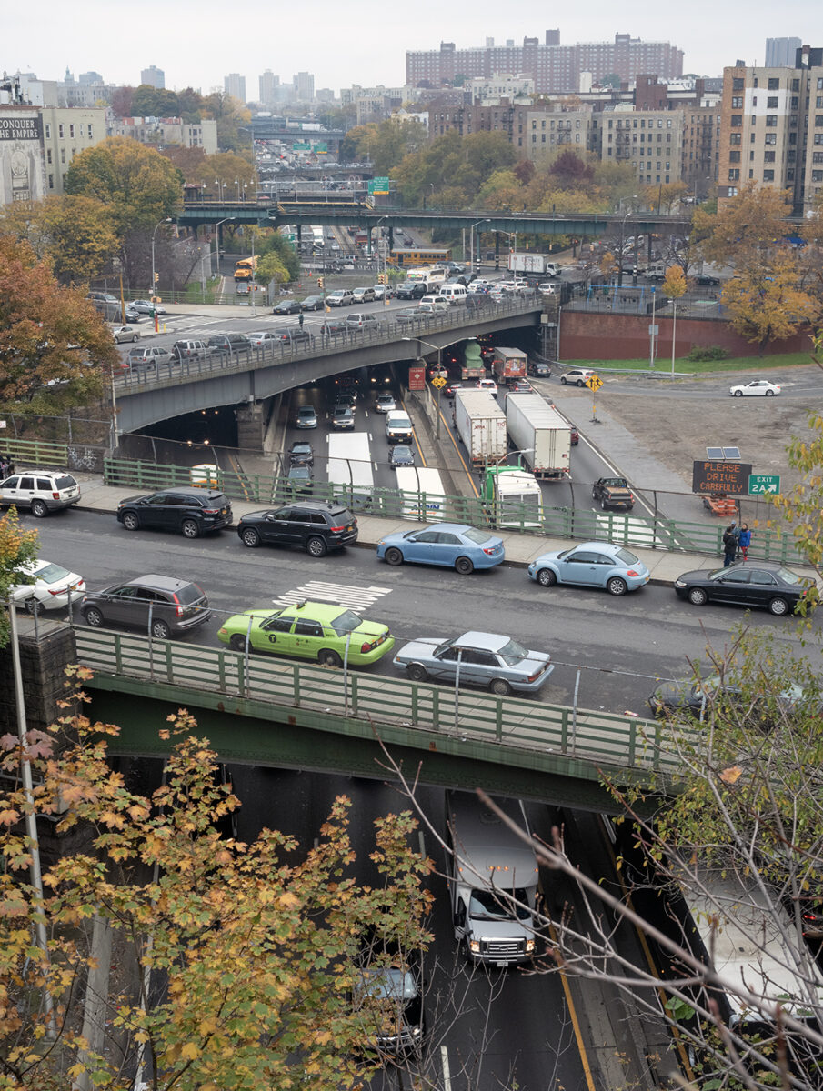
Begun in 1947 the project crossed 113 streets. Subway lines. Elevated trains. Water mains. Sewer lines. Fifty-four bridges. Three tunnels. And it displaced roughly sixty thousand people.
Sixty thousand.
They are rarely centered in the story. Why?
The man who built it did carry racial prejudice into his work. Riverside Drive’s infamous monkeys ornamentation stands as proof enough. But Moses’s primary bias wasn’t racial in the modern sense. It was class. He was pro-middle-class, aggressively so. The Cross Bronx displaced working-class whites, full stop.
The Manhattan cut coming off the George Washington Bridge, much of it covered by the Bridge Apartments, is a different animal. It removed tenements that sat directly in the path, but the street grid survived. Cross streets still cross. In the Bronx, they don’t always, although in the deepest and most populous neck of the Trench, only three cross streets were lost. Like the Bronx at the time, that part of Manhattan was largely white, working-class, Jewish or Irish, with Blacks, and nobody was eager to leave.
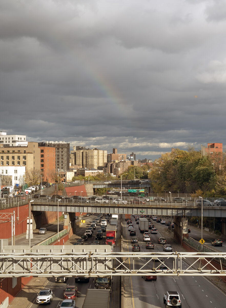
CROSS BRONX EXPRESSWAY THROUGH MANHATTAN
it’s strictly working class and and the pollution problems still remain. All this in a neighborhood that was already extremely densely populated. The point is, that’s why my apartment in Williamsburg before gentrification encouraged mitigation and improvements, was cheap as shit. Because it was shit. I just didn’t know it at the time. It was, simply, home.
So be it with these towers. For cheaper rent the sacrifice is breathing pollutants and great location. Something i did throughout my life until, at the age 72, i got a nice place to live further north, uh, where most people after paying their dues in the south Bronx.
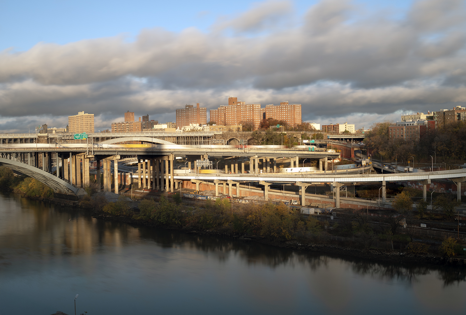
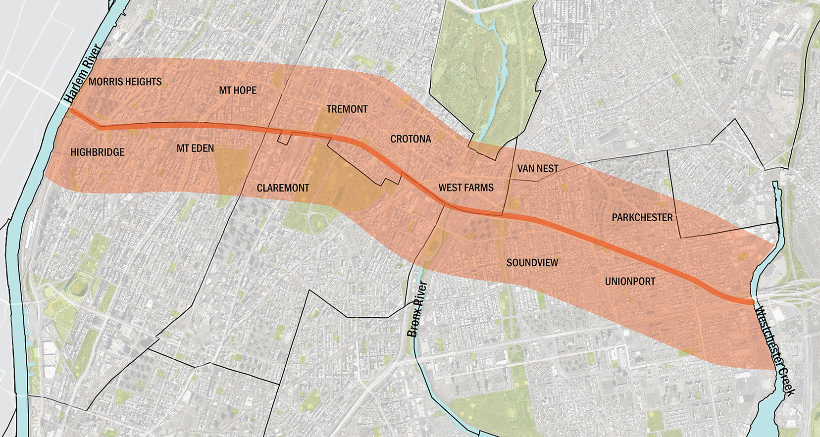
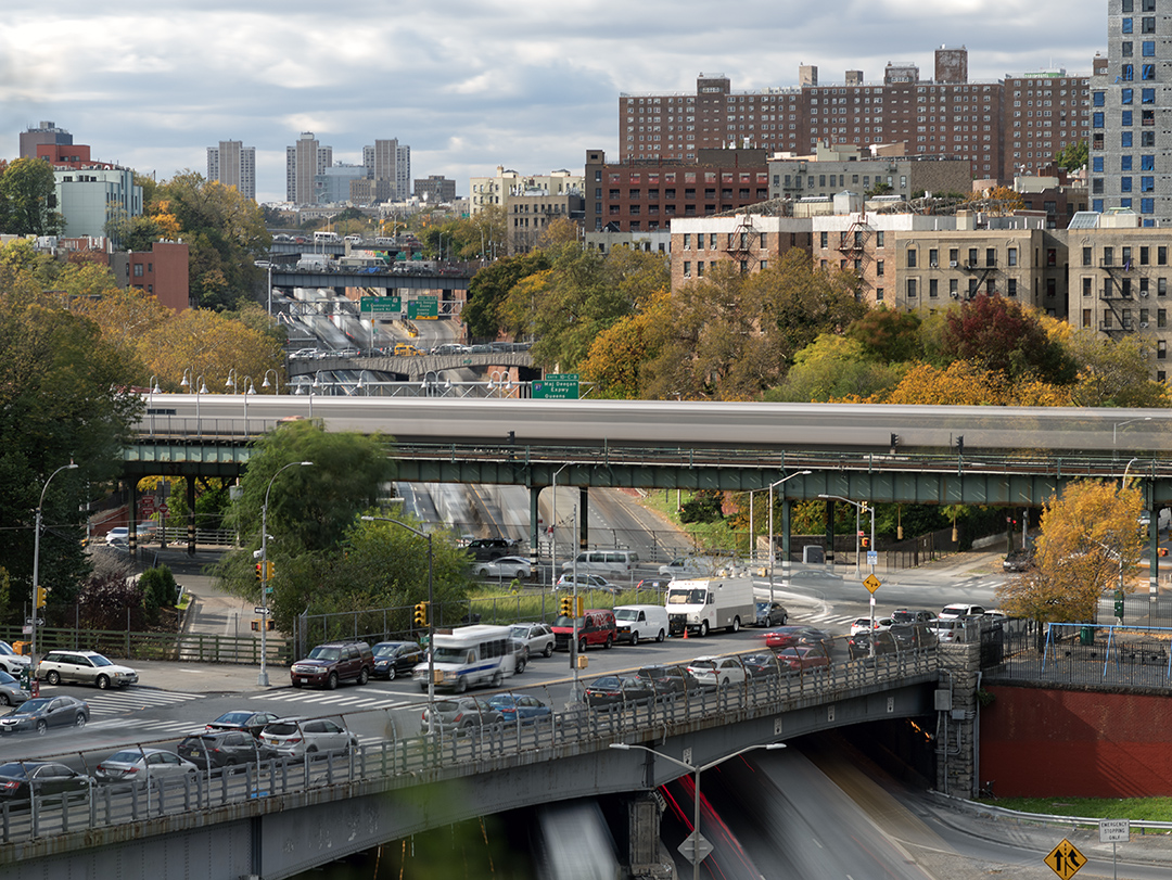
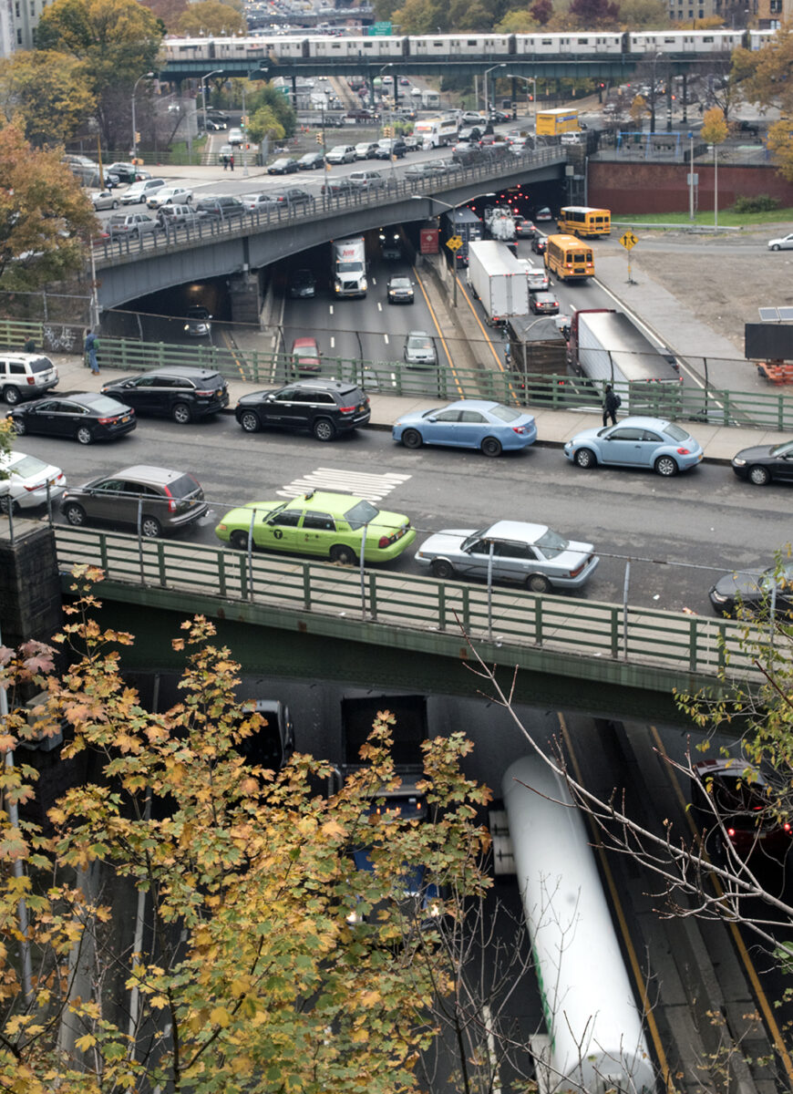
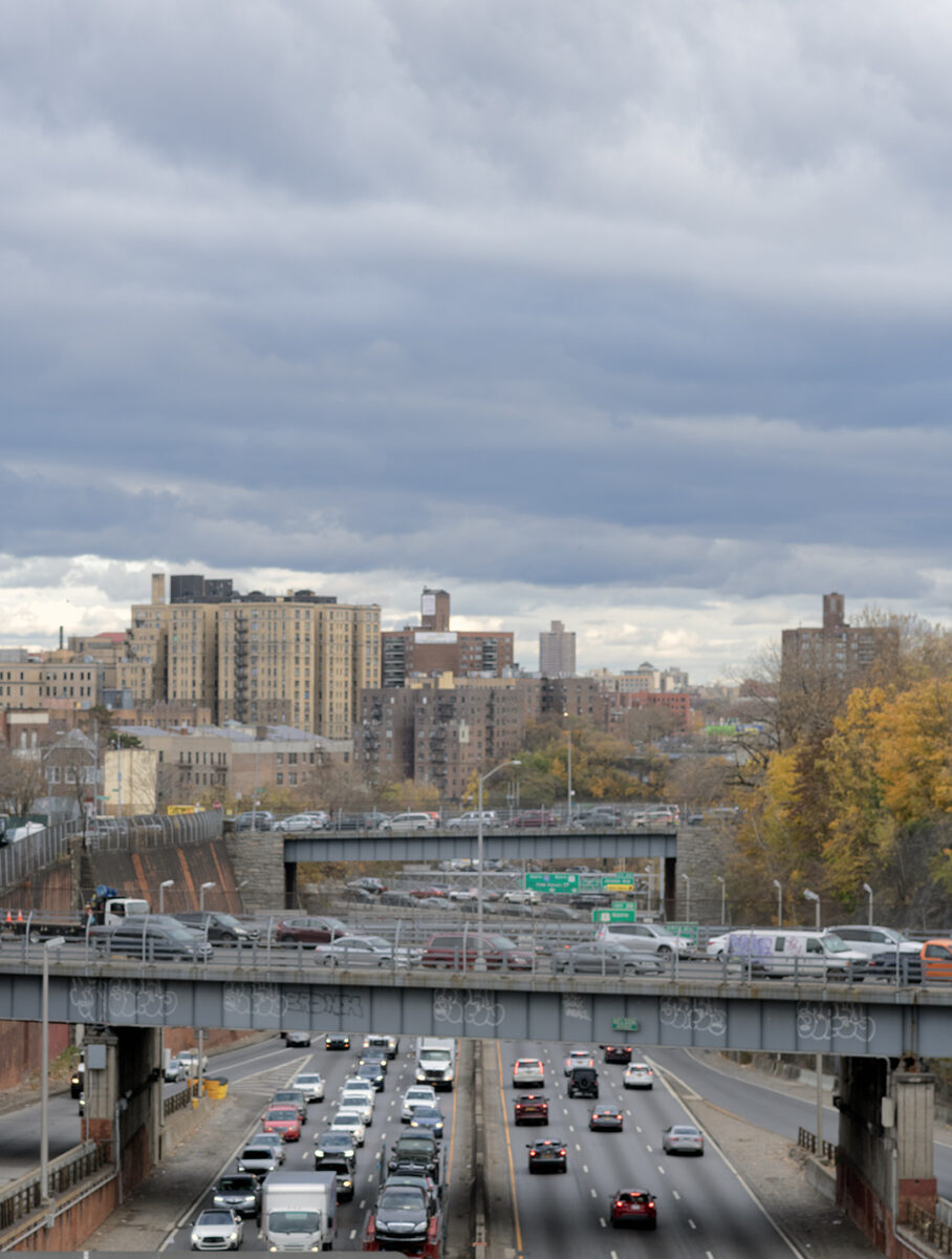
After the Manhattan trench interstate 95 crosses the Harlem River Valley, and becomes the Cross Bronx Expressway upon landing into the The Bronx Cut. This where th damage concentrates. It’s the deepest section of the trench and displaced the most people, running east from University Avenue to to the Grand Concourse, where it cuts through the ridges, running north and south that make up the west Bronx. After tunneling through the ridge that carries the Grand Concourse and it’s subways, the trench shallows, widens, and finally relaxes as it approaches the Bronx River Parkway, ending at the Bruckner.
A direct shot almost a straight line directly through New York City, including Manhattan and the Bronx. Construction began in 1947 and continued until 1972 whose timing coincides with the biggest negative changes in the history of the Bronx. How much of history is, because of this, symbolic, and, how much of its history is real?

There was no home air conditioning when it was built, let alone, air filtration systems and windows that don’t even open. And one of the most important facts is that it was built well before the banning of leaded gas. That’s very significant.
When i was shooting this an interesting and revealing event occurred. Three Peruvian urban affairs interns, in NYC, to study and help resolve problems associated with the CBE, came upon me and introduced themselves. Of course, the problem was racist infrastructure. More about this later.
At the time, the neighborhoods being erased in East Tremont and Morris Heights were overwhelmingly Jewish, with strong Irish and Italian blocks. In the mid-1940s nearly half the Bronx was Jewish. Somewhere between 650,000 and 750,000 people. Grand Concourse apartments. Synagogues on corners. Union wages. Buildings maintained.
Flying into New York you wouldn’t know about the fact that it took 24 years to complete the project from 1948 to 1972. That wasn’t a little bit of time in urban history, and, in terms of the Bronx that was an era. After World War II, there was no change in thinking in these neighborhoods. People were here, and they liked it until Robert Moses planned a straight shot through it in the most efficient way possible. It was the straight-shot trench. And there was a lot of other things happening as well like the building of Co-Op City in 1968, which offered the same breath of fresh air for the same people when they first came to the Bronx in the 1920s from the slums of Manhattan. The neighborhoods the CBE tore through are all temporary places until you make enough to depart to better places – or get booted out like the Jewsih folks displaced in 1947 which signalled the working-lass as expendable.
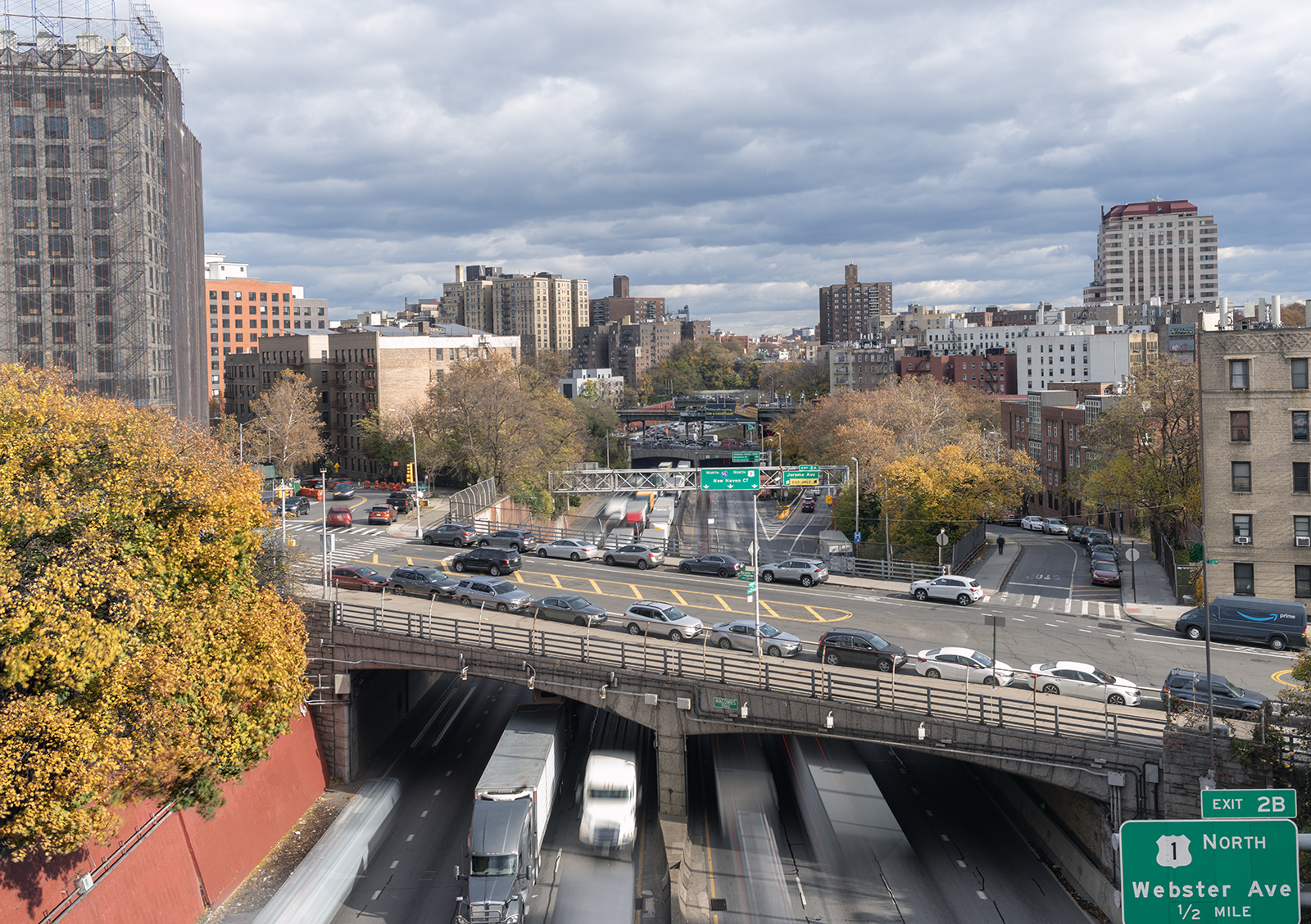
CROSS BRONX EXPRESSWAY LOOKING EAST
The deepest part of the cut occurs between University Avenue and the Grand Concouse. These shots were taken along streets that Cross the Expressway that were left – University, Nelson, Jessup and Macombs. Entire blocks cleared. Families uprooted. Buildings cut in half. Most of those displaced were Jewish, Irish, and Italian, largely working-class. Sixty thousand people removed so a straight engineered line could run from the Hudson River to the Bruckner Interchange.
That was the first disruption.

Construction began in 1947. The George Washington Bridge had opened in 1931. By the time the Trans-Manhattan Expressway was cut across upper Manhattan, you could drive from the Hudson to the Harlem River without touching the old street grid. The Cross Bronx extended that incision another six and a half miles east. From river to river, roughly nine miles of uninterrupted will.
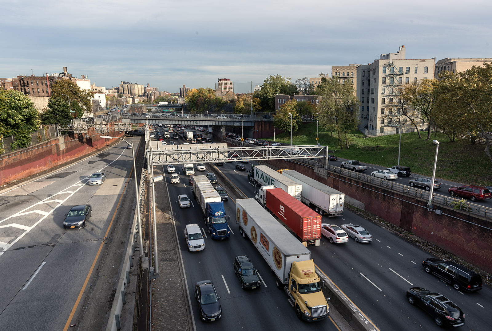
One thing that’s certain the CBE was built on a straight line favoring drivers crossing the city to get to I-95, and it’s a trench and not a tunnel. Being a cut and not a tunnel is often criticized on the grounds of pollution and, at least, in the Bronx for sacrificing numerous cross streets, which is the actual barrier. But could a tunnel also provide off ramps to Bronx local streets? When it was built traffic pollution was at all-time highs, before a ban on leaded gas. There was little use of air conditioners and, in New York, windows are kept open in winter due to excessive heating in large buildings. Today much housing that lines the trench is new with central air with filtration and often windows that are permanently sealed.

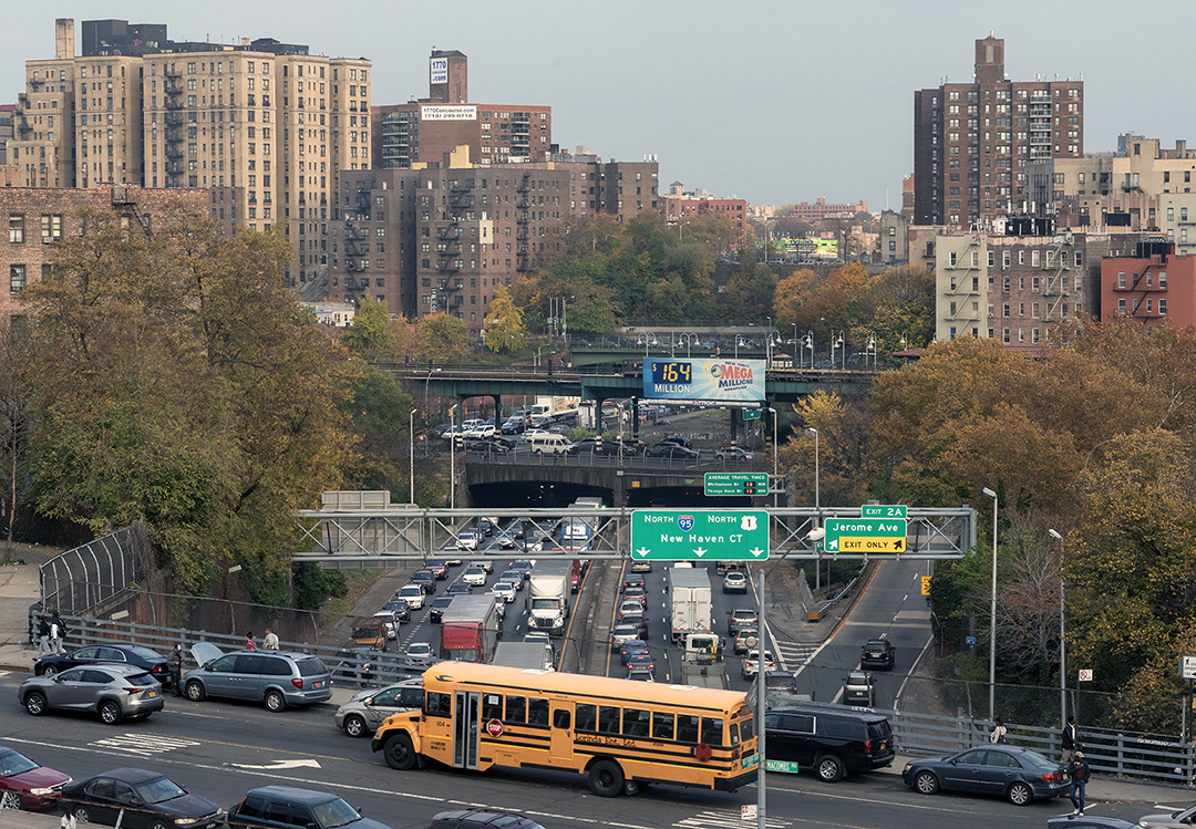
I was taking pictures of people begging on the Cross Bronx Expressway and it started to rain. I held my position on top of my ladder to shoot over the fence on McCombs Road and have a good look at the CBE. My camera started to get soaked as well as the lens so i sat in my double parked car for five minutes until the rain let up and when I went back to my ladder, this is what i saw. Probably a little more difficult to handle if this was a tunnel with no access to the local street.
Looking east from Nelson Avenue
Originally these neighborhoods that were leveled were predominantly Jewish, as was the entire Bronx, as well as, Robert Moses, who was racist, but was mostly pro-middle-class and if callously displacing working-class Jews, doesn’t explain things, than what does?
Another factor to consider is that particularly in New York City, which is an immigrant city, these neighborhoods, especially the West Bronx neighborhoods have always been, historically, steppingstones and no one group usually never stays permanently. It’s in a constant state of flux, and the movement is towards the north often into Yonkers, Mount Vernon and New Rochelle. I lived most of my life in Brooklyn before being illegally displaced into the Bronx. My Brooklyn neighborhood, compared to the Bronx, was unusual in the sense that the ethnic group that was dominant had been there since 1880, that is, until the place gentrified, but, still today, there is a large Italian presence in Williamsburg. The west Bronx in particular, after the Germans and Irish, was strictly a stepping-stone to a better, less crowded place whether folks left by their free will or not.

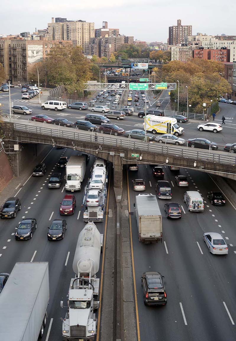
Looking east from Jessup Avenue. It truly would’ve been a disaster if the cross streets north and south were taken out. Truth be told, only three streets are no longer connected by bridges.
The fact of the matter is that in the deepest most densley populated section of the Trench only three cross streets were taken out permanently, and some after the CBE tunneled underneath the Grand Concourse where it soon becomes an elevated roadway, before going back into a much shallower cut.
The small spaces left for trees and parks now have 75 years of growth and new buildings dominate the edges of the Expressway in a new boom cycle for the Bronx where no one is thinking they can’t invest here because folks are walled off, separated by a moat of racial hatred and would never live in such a polluted hell hole if it were all true. Like i said earlier i found a great place i wanted to live next to the Trench at University Avenue, not concerned about dying of cancer from pollution. That had already occurred anyways from a life in a Brooklyn neighborhood, by far, the most polluted in the city. Industrial and traffic.
If the CBE was a tunnel would there have been exit/entrance ramps for accessing local streets? The CBE was built between 1947 and 1972 and has evolved in to the dominant symbol the the devastation from those years. The Bronx Cut only gains in its symbolism of borough destruction through division of the county by cutting it in half. A border, a barrier, a wall? First of all, that’s really hard to do and one of the most ethically changing areas of New York. What nationality claims a Neighborhood their own that’s always only on a temporary basis in the Bronx, where people particularly in the West Bronx are built to move on. Even though they sometimes build generational neighborhoods that seem permanent and invincible often the fact of the matter becomes a fight to hang onto their neighborhood only to be shoved out, but through this process, find that there are much better places to live in the north. This has been the same story in the Bronx since it began to develop after 1890.
If the CBE was a barrier to growth to the south, it was temporary, as was the actual border between the two. The threshold for the borders of the “South Bronx” began in Mott Haven around a pocket of poverty on Browns Place in the 1920s and continued up the Bronx, past the CBE and ending at Fordham Road as the last stand against blight in the borough. Of course the straight-ass trench was a physical mark on the landscape you could fill with opinions, even from a thousand miles away.
CROSS BRONX EXPRESSWAY LOOKING WEST
The deepest section of the Cut looking west where it goes under the 4 Train and Jerome Avenue which runs north and south underneath the elevated and runs in its own little valley. Only three cross streets were sacrificed in this entire stretch of the CBE. After reviving very slowly until well into the 2000s, the Bronx exploded into full development mode as seen here where the new much larger apartments with sealed climate controlled infrastructure tower over the older five story walk-ups.

To cover this is ridiculous on a cost level alone. They just spent $10 billion on flood barriers for lower Manhattan and much more is needed just for that. What original temps are left on the cross street over the CBE are now dwarf by huge apartment buildings with hundreds of units, sealed windows and climate control. To repeat I’m only against it on a cost level because all things are relative and to spend $20 billion you better be thinking.
Puerto Ricans in 1945 were a small minority, roughly two to three percent of the borough. The large migration from the island was just beginning. They were present, yes. But they were not the primary population living in the direct path of the clearance.
That is arithmetic, not sentiment.
Robert Moses was Jewish himself, the son of German-Jewish immigrants. His bias was not racial in the modern vocabulary. It was class. He believed in the upward arc of the American middle class. Parks. Beaches. Highways. Motion over memory. The Cross Bronx displaced working-class whites, full stop. That does not absolve him. It clarifies the frame. If it makes it any better Mr. Moses disliked working-class and slum Blacks and Puerto Ricans more. That’s his only punishment deliverable and it’s a big one because historically they go down as you know what. After documenting that it’s time to get on with our lives.
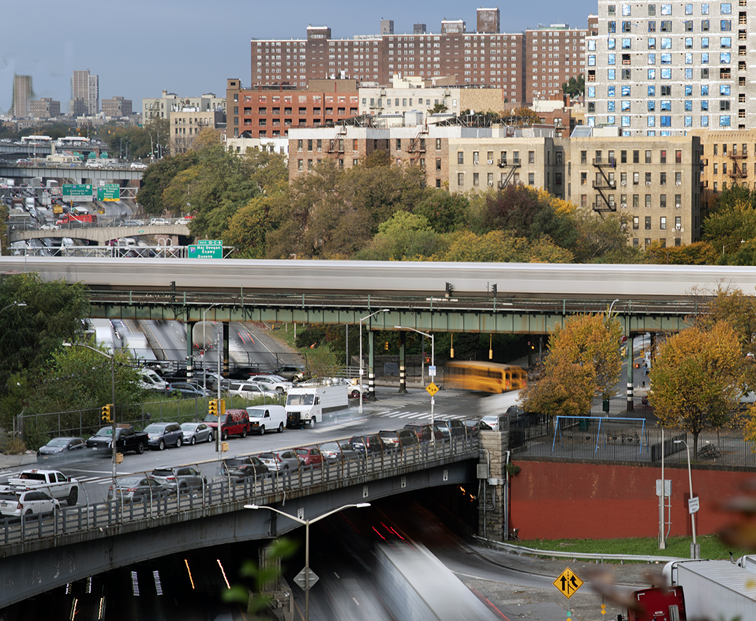
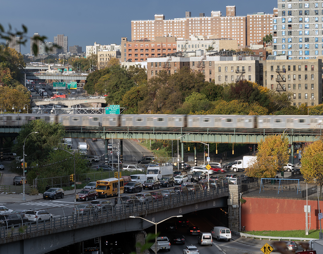
Looking up the Cut from above its deepest point, it’s clear that over time redevelopment on a very large scale was more than possible. The original north/south infrastructure of train lines and streets being untouched was never going to go to waste, especially as affordable private housing became scarce all over the city, except the Bronx where it has held the line better from inevitable gentrification. And, believe it or not the expressway makes for some very handy shortcuts for locals if you know the streets. For instance, you can jump on at Jerome Avenue to get to the Deegan Expressway quickly because you have your own lane once you enter the Cut all the way to north and south access on the Deegan. I could hit the Deegan and make it home to Forham Road at Sedgwick Avenue in no time.
When you talk about traffic pollution things have changed significantly beginning with the transportation itself, which no longer uses, leaded gas with vehicles designed with advanced pollution control, leaving the tractor trailers and their diesel as the primary sources of pollution on the expressway. But remember, this was always a beef about a large infrastructure project going directly through multiple neighborhoods from East west in the Bronx. Well, many other neighborhoods had pollution coming from existent industry, as well as similar expressways in size and scope.
The working-class, no matter the nationality or religion are expendable in the name of mobility. That was the first disruption.
The Cross Bronx Expressway was Robert Moses with a map and a belief that the future had wheels.
Moses was Jewish himself, the son of German-Jewish immigrants. He believed in the upward arc of the American middle class. Parks. Beaches. Air. Roads that carried families out of crowded blocks toward something cleaner. He believed in motion more than memory.
The Jewish population was half the Bronx and Puerto Ricans in 1945 were a small minority. Two to three percent. Maybe 30,000 to 45,000 people. The migration from the island was just beginning. They were in the Bronx, yes. But their numbers were low, and they were not the primary population living in the direct path of the expressway clearance in East Tremont and Morris Heights. That corridor was overwhelmingly Jewish, with strong Irish and Italian working-class blocks. That is arithmetic, not sentiment. Certainly not politics.
Then the hinge turned, partly spurred by the building of the CBE starting in 1947, but also coinciding with the broader interstate highway era and the new ability of working-class and middle-class people to move.
Through the 1950s and 1960s, Jewish families moved outward to Queens, Long Island, Westchester. Not as refugees. As aspirants. GI Bill mortgages. Better schools. Lawns. The middle-class arc. Also made possible by the creations of Robert Moses.
At the same time, Puerto Rican migration surged. American Blacks moved north from Harlem and other parts of the city. The demographic balance did not inch. It swung.
By 1976, Puerto Ricans made up roughly 25 to 30 percent of the Bronx, somewhere around 300,000 people. The Jewish share had fallen to perhaps 5 to 8 percent. In one generation, the borough shifted from majority European to heavily Puerto Rican and Black American.
That is not prejudice. That is arithmetic. And what math, proving, unlike my home in Williamsburg, these Bronx neighborhoods have turned out to be ever-changing and pinning it with slogans is not productive and getting boring.
The physical condition of the borough changed along that same arc. Before the fires, there was deterioration. Buildings that had once been maintained and occupied became unstable, then neglected, then partially empty. The “narrative” that has been built for so long about the greedy landlords hiring folks to torch their prpoerty leaves out the folks of those neighborhoods involvement in the deterioration for whatever the reasons.
When you cut a six-and-a-half-mile trench through the densest borough in the city and displace sixty thousand residents, you do not leave stability behind. Blocks become transitional whether they want to or not. Property values shift. Noise increases. Traffic roars. Some residents leave because they can. Others move in because the rents drop. That’s the documented disruption created by the CBE. Nobody with options chose to live next to a roaring expressway. Whether it’s I-95 in a Trench or I-278 Elevated where traffic passes closely to third floor apartment windows through Williamsburg and Greenpoint.
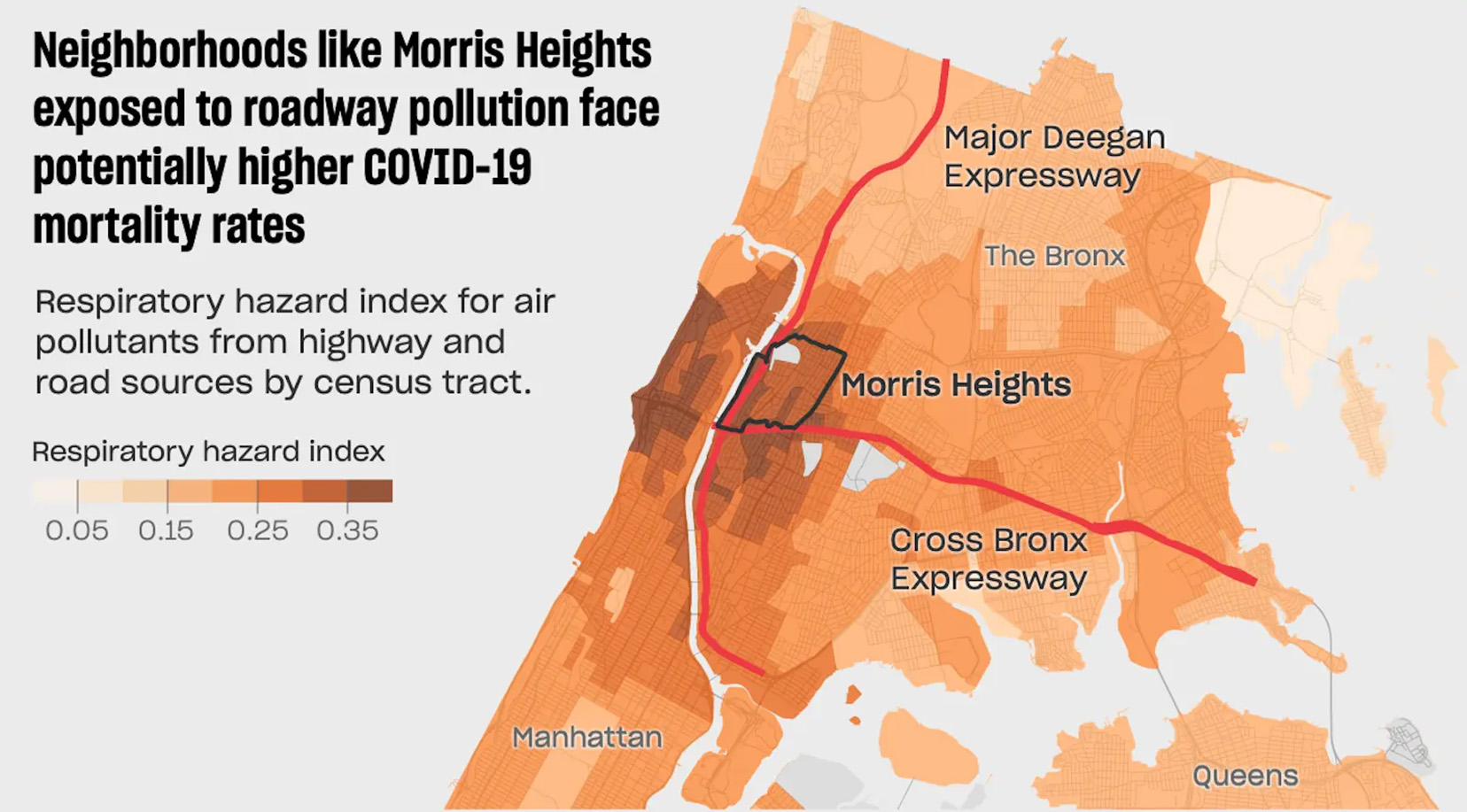
But that was in 1947 and the entire Cut took 19 more years and covers the entire Bronx is burning era. The symbol of racist infrastructure is a crystalization and compression of the era from what’s considered the Great Bronx Fall. “The CBE cut off neighborhoods of color in the South Bronx from more affluent white neighborhoods in the North Bronx, resulting in disinvestment and poverty.” According to Robert Caro, writer of The Power Broker, the decision to run the CBE through Tremont was intentional and racist. Talk about seeing things in black-and-white? I’m not even gonna comment.
Too simple. Charlotte Street, not near the CBE, later became the same sort of symbol. Presidents toured it. Cameras framed it. Rubble against the sky. The worst street in America. But streets do not wake up and decide to burn.
By the mid-1970s you could drive that nine-mile corridor from the Hudson to the Bruckner and look down into blocks sealed in plywood. Windows painted to look like windows. Curtains. Flower pots. A stage set for drivers moving at sixty miles an hour.
What is remembered is the image of greedy landlords hiring poor tenants to torch buildings for insurance money. What is remembered less clearly is the order of events displacement, demographic shift, visible deterioration, fire, then demolition.
The Cross Bronx had already been running for roughly twenty-five years by the time the borough became shorthand for burning. It fractured neighborhoods. It depressed values along its trench. It signaled which blocks were expendable. But it did not strike every match.
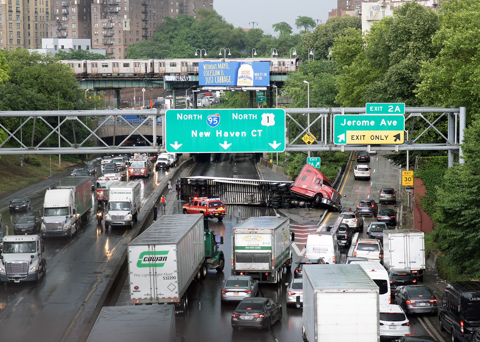
Why wasn’t it a tunnel?
Cost. Tunneling in the late 1940s would have been dramatically more expensive than open-cut construction.
Time. Moses built fast and overrode objections. Political calculus. Working-class neighborhoods did not have the leverage to force a slower, costlier alternative. Era mindset. Mid-century highway planning prioritized automobile throughput over community preservation. Urban fabric was not sacred. Traffic flow was.
A tunnel would have preserved the surface grid. Instead, the trench fractured it. In the deepest section between University Avenue and the Grand Concourse, the expressway cuts through the ridges of the West Bronx and drops into a concrete channel. Some cross streets were lost permanently. Others bridge over. The damage is not theoretical. It is physical.
But the story does not freeze in 1947 with 60k booted out. Through the 1950s and 1960s. Jewish families moved outward to Queens, Long Island, Westchester. Not as refugees. As aspirants. GI Bill mortgages. Lawns. Better schools. The same mobility Moses believed in.
At the same time, Puerto Rican migration surged. Black Americans moved north. By the mid-1970s, Puerto Ricans made up roughly a quarter to a third of the Bronx. The Jewish share had dropped sharply. In one generation the borough’s demographic balance swung.
When you cut a six-and-a-half-mile trench through the densest borough in the city property values shift, noise increases. Some residents leave because they can. Others move in because rents fall.
By the mid-1970s the Bronx became shorthand for burning. But the sequence matters: displacement, destabilization, deterioration, fire, demolition. It did signal which blocks were expendable, working-class but a new wave. The burning Bronx is true, of course, but no one torches quality buildings maintained and fully rented.
In recent years the expressway has been crowned the flagship example of “racist infrastructure.” The phrase travels well. It simplifies. The history is more complicated. by the late 1980s there was change and it surged beyond belief by 2015. In the 1970s, I lived in Belmont and remember that the dividing line between the north and south Bronx had become for all intents and purposes Fordham Road. I remember many people wanting to preserve the housing north of Fordham Road simply to preserve what was there. That sentiment didn’t seem to me to be racist. Particularly when the border between the north and the south Bronx, which began on Brown’s Place in Mott Haven in the 1920s slowly and always shifted north past 149th, Tremont, Burnside and exhausting itself around Fordham Road. The newcomers from the south weren’t blocked and eventually most neighborhoods above Fordham Road were Puerto Rican, then Doninican. I lived at Fordham and Sedgwick and saw the change from Irish/Jewish to Puerto Rican and then Dominican and Carribean. That west Bronx Spine on its highest ridge supports those lines of brick tenements past Gun Hill Road.
On both sides of the trench today you see largely the same nationalities. Dominicans. West Africans. Caribbeans. But also Yemenis. Albanians. And a lot of Mexicans. The folks change. The buildings remain. Most north-south streets still function. People cross the expressway daily without thinking about it. On University Avenue and the Grand Concourse the Cut is hardly visible.
The trees planted along the cut have grown for seventy-five years. New apartment towers rise where five- and six-story walk-ups once defined the skyline. The borough written off in the 1970s is in a construction boom. Affordable housing pressures in Manhattan and Brooklyn push people north again, just as earlier generations moved outward.
Six and a half miles of expressway. Roughly nine miles from river to river. A straight shot through the borough. A severe cut.
But not fatal. Cities metabolize damage. They carry scars. They shift populations. They rebuild around infrastructure that once seemed definitive. The Cross Bronx Expressway fractured neighborhoods and depressed values along its trench. It did not end the Bronx.
What was lost was real. What remains is larger. The road stays. The city grows around it. Moses left alomost every cross street and train line.
It is easier to compress the story into greed and prejudice. Harder to accept that structural destabilization unfolds over decades. And here is where the symbol starts to loosen.
The Cross Bronx was supposed to be the permanent dividing scar. North versus South. Before versus After. Ethnically things shift always in the Bronx, the poorest borough with the cheapest rents. Both those facts feed off each other.
Yet the ethnic map shifted again.
By the 1990s and into the 2000s, Dominicans became the largest populations in the Bronx, in many neighborhoods replacing both the Jewish communities that left decades earlier and the Puerto Rican majority that defined the borough in the 1970s.
And the churn did not stop there.
Today the West Bronx is layered again. Dominicans. West Africans. Caribbeans. Yemenis. Albanians. New storefront languages on blocks that once held kosher butchers, then Puerto Rican bodegas, then Dominican salons. The buildings remain. The signs change.
On both sides of the Trench you now see largely the same nationalities. It is not north versus south. It is one demographic fabric laid over a scar. With the exception of a few north-south streets sacrificed during construction, most cross streets still function. People move back and forth every day.
The expressway is loud, polluted, sometimes a hindrance. It’s not a wall, border or dividing line if it ever was in a shifting burning rebuilding Bronx. Crossing over the CBE is easily done and nothing changes once done. No one thinks about it. We’re busy. We live here.
The trees planted along the cut have grown for seventy-five years. They rise above the traffic now. What was once raw concrete is lined with growth that did not exist when the road opened.
New apartment towers rise where five- and six-story walk-ups once defined the skyline. Developments so large they make the old tenements look miniature. Cranes where rubble once stood. The borough written off in the 1970s is now in the middle of a huge construction boom, not only from the usual immigration waves, but from a migration out of Manhattan and Brooklyn into more affordable housing with convenient access to transportation. Discovering good things in the Bronx much the way earlier generations once did, except today it is about cheaper rent and proximity.
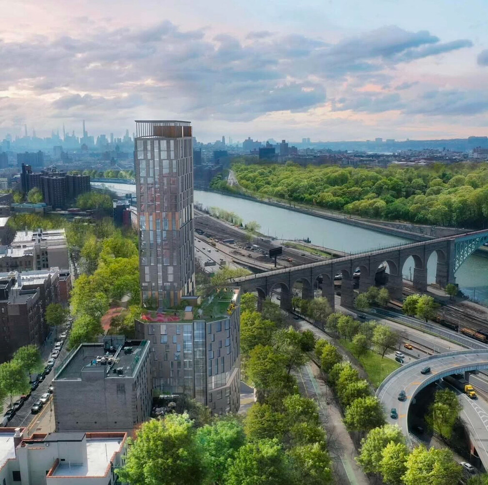
High Bridge is a 442 unit mixed use architectural wonder opening in 2028 in the middle of the entrance and exit ramps for the Cross Bronx Expressway and the George Washington Bridge. It’s the intersection of I-95 anf I-87 in the busiest largest interchange infrastructures in New York. It’s for recovering addicts and the poor only. There’s proof all over these toxic expressways that they’re viable as real estate and that the Bronx Cut has healed a lot. Giving this quality housing and architecture to the bottom economic rung? Instead of projects? And what also must be said is that if you built luxury housing next to the Cross Bronx Expressway that would sell out in a very short time.
Six and a half miles of expressway. Nine miles from river to river. A straight shot through the borough, no doubt. A cut, and a severe one. But not fatal. What was lost was real. What remains is larger. The road stays. Adapt, resist or forget.
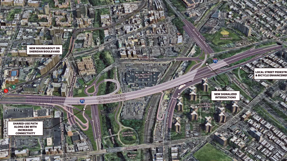
This is the non-trench stretch of the CBE, over the Bronx River and the Bronx River Parkway. It’s a Plan to utilize the open parts of the conduit for bike paths and pedestrian walkways and bridges. For instance, you could bicycle along the cross Bronx Expressway and take a ramp down at the starlight Park, which is a fresh new and beautiful park that has taken over the land where the old amusement park used to be and burned down long ago. Already today there is a good section of the CBE that is covered with a park and playground as well as a school. It’s called Prospect Park. This is entirely feasible in this eastern end because the trench is very shallow and defined. Not like the Western end between the grand Concourse and University Avenue, which is huge deep and open space with no sheer walls, but cut stone. In order to cover the section it would be just too much you’re talking $10 billion? And this at a time when the city just spent that much on flood control for lower Manhattan for the oncoming seasons of flooding that began with hurricane Sandy.
I tried to get into a building on University Avenue directly above the Bronx Cut, but didn’t quite qualify. And I’ve been here before it was thee “white guy” thing. Then i saw Highbridge, my desire to live there blinded me to the fact that I couldn’t get into there either because I wasn’t that far on the low end and I wasn’t a drug addict. How about that the board of the poor and the druggies live in one of the best architectural developments in all of New York with absolutely the best views. With the Bronx booming like it hasn’t since the 1930s, it’s a wonder that people are still attached to the symbolism of racial barriers and borders and landlords burning down their own buildings. All that is so far gone and pretty much revisionist, but, it’s a massive redevelopment of the Bronx that makes the symbol shrink and, foe me, buried by its history and suimple truth and fact.
Like the streets, the vegetation and the new apartment buildings, you can get over it today literally and symbolically, as the Dominicans, Africans and Caribbeans are doing right now. Adhering to a history of infrastructure caught up in the worst economic times a borough has ever seen, is long-gone because of the massive redevelopment in the last ten years has made nearly every bit of real estate valuable again. Try to find an abandoned building or home in the Bronx today as proof.
There is a section of the CBE that is covered. There is a school and playground built over it on its eastern end. It’s very nice. But to cover the deepest and longest stretch between the Harlem River and the Grand Concourse is very expensive. Like in any expanding city with housing shortages, rents rise while others who can move to healthier places, leaving room for new dues-payers.
Truthfully, the five- and six-story walk-up canyons with no greenery that run up the spine of the West Bronx ridges, if you pay attention to their history, semed designed for maximum occupancy and profit. There’s always an arriving nationality that’s broke and need a cheap place to stay with similar folks as themsrlves. People moved on when they could. Even the West Bronx infrastructure, where highways and large boulevards run north and south, reflects that migration flow toward Westchester County or New Jersey.
The evolution of the symbolism associated with the Cut is spoken confidently by people who usually do not live here. For those who do, it is more or less permanent infrastructure seen daily and is now dwarfed by huge aprtment buildings in the big bad Bronx redevelopment phase.
Personally, the hardest aspect of Bronx urban renewal was the slum clearance that removed massive chunks of neighborhoods for purely functional towers. That was a loss measured in texture and street life that bothers me every time i see them. What a loss. Street grids, historic blocks of inhabited homes vanish for this? I really dislike looking at the projects and don’t mind glancing at the CBE. As chairman of the Slum Clearance Committee in New York City until 1960, Moses advocated that the best way to eradicate “slums” was to build highways through them. In a 1959 speech, he argued, “[w]e can’t let minorities dictate that this century-old chore will be put off another generation or finally abandoned” and thus highway construction “must go right through cities and not around them.
After having lived most of my life near the most polluted section of New York City and then moving for 13 years to Fordham and Sedgwick in the Bronx, there i found the heaviest air pollution I’ve ever breathed since leaving Williamsburg against my will. The most polluted, by far, place in NYC, where they’re still pumping a 30 million gallon oil and gas spill underneath northern Greenpoint discovered 1987 and created in 1898 when 50 oil refineries lined Newtown Creek, the border between Brooklyn and Queens. In 1978 the last slaughterhouse along Newtown Creek was shut down by the EPA in 1987 the Greenpoint incinerator which burned waste from around the boroughs was shut down. By 2000 the open sedimentation tanks that received 25% of the city’s shit and sewage was finally closed.
I remember waking up one night at 3 AM in Williamsburg in my apartment and couldn’t breathe. I’m talking COVID-19 couldn’t breathe. I finally passed out and learned there was a tremendous diesel spill in the East River just blocks away and the predominant wind from the west blew it through our open windows.
So you can’t tell me much about pollution, infrastructure and borders. That’s one of hundreds of toxic encounters in daily life in pre-gentrification Williamsburg. Leading to sarcastic comments ike, what’s next, racist geography? But it can’t hold up in a changing world and this world has changed a lot since 1948. Near its eastern end, the cut is very shallow. The building is quite low and the sky is open here like everywhere else along the CBE. There are new apartments that you can look at. where windows look down at the CBE. Judge for yourself – 2250 per month for a one bedroom next to the CBE, new construction. Nothing’s burning anymore, in fact, it’s building like crazy.
Polluted neighborhoods? Yeah, that’s a real concern. But the truth, more so. Racist infrastructure? The way Moses built the Brooklyn Queens Expressway tells the truth. When it had to pass through Brooklyn Heights, instead the BQE was cantilevered over itself on the side of the Heights. As soon as clearing that wealthy neighborhood it tore through Fort Greene, and a straight shot through Williamsburg and Greenpoint which were historically incredibly working-class. Not bums, just hard-working people from around the world.
Many older cities went through the same scenario. All had slow returns. So what remains? Many things and much loss. Not compensation.
The Cross Bronx Expressway was the first attempt at putting an interstate through dense existing neighborhoods. It was cut deep. For a reason if you actually think. The CBE in the west Bronx began at its highest ridge. The trench went down to Jerome Avenue, then up another ridge through a tunnel supporting the Grand Concourse and its subway lines. From there it emerges around Webster Avenue and where the trench disappears, the road becomes elevated and then goes underneath a playground and school built over the road after the CBE was built. After that it’s unremarkable and not much of a trench. Three possibilities existed – tunnel, cut or elevated.
One To say the CBE prevented the poor from moving to better neighborhoods to the north is a blunt untruth. Starting with the south Bronx neighborhood, Mott Haven – it was built mostly between 1880 and 1920 when the population of the Bronx was 89.000. Its homes were essentially suburban middle and upper class and it was fairly stunning. The real crime going back to Moses was his “slum clearance” which tore out much of Mott Haven’s streets. As far as the South Bronx massive deterioration the first question before its burning is who left, who replaced them and who is responsible for the deterioration that created the environonment of crime. Even the crime of arson for hire.
another crime is the exagerration of the symbol that the CBE has become being exploited, for instance, stalwarts of morality, like law firms that use photographs that are not the CBE and make bull shit statements like “This one expressway completely destroyed the borough” Close to what many want the actual history of the borough to be.
But the borough did not end. Because no barrier was created and no hard borders based on racism happened in the historic record. Outside of that, and, in people’s minds it’s a different story to hang your ideas on. The event was metabolized because a living entity didn’t ask for it it and had to overcome it. Cities do that. They metabolize damage. They carry scars. They outlive planners. Shit changes even as perceptions remain the same.
After wrting this i was researching and came across this which has similar conclusions about looking at history before 1970 instead of beginning the Bronx history with its decline.
https://urbanomnibus.net/2025/10/a-century-of-cross-bronx-developments/
https://theneighborhoods.substack.com/p/east-tremont-the-bronx
Angry but nevertheless experienced.