
In 1978 i began shooting industry and accompanying toxic waste sites. Generally speaking, I’ve shot the some of the most forgotten landscapes within American cities. Through much of this my base of operations has been in north Brooklyn, which, conveniently, borders one of these noxious desolate factory zones that lie in the midst of populous urban areas. Gradually, by 1986 Newtown Creek and its environs became my default location for shooting industrial America, its waste and its neighborhoods. That is to say, if I couldn’t make it to sites in New Jersey, Ohio or Montana there was always the nearby Newtown Creek where I could walk to my locations. A place I simply called the B/Q.
This is Newtown Creek, also known locally as “Noo-un Creek.”
And in the Creek and its canals, particularly at low tide, I learned to call that, the Bad Water Bottom, from the Indian name, Mespat, later Maspeth. To many Newtown Creek might be known as America’s most polluted stream, but that was not foremost in the documentation. The majority of the pollution shots came much later, mostly between 1998 and 2002. This is when the B/Q Bottoms were ripe – at their most recently vile, smelly and visible peak – just as serious remediation began to take hold.
The industries, infrastructure and miscellaneous enclaves were the draw and I shot them at their peak too. The B/Q, so rigged out for transportation by land, water and air, along with its cemeteries, manufacturing and neighborhoods, could use some documentation beween 1986 and 2012. Especially since the Brooklyn-side of the Newtown zone bordered on an area moving swiftly away from slums and working-class life to luxury living. Some important industrial monuments were about to fall.
In the many years before the discoveries made by the photographers known as urban explorers, there were natives who knew the terrain and its origins. For them, the old industrial land and its geography were never mysterious places to contemplate or imagine what “it was like,” nor, an empty vessel of reinvention for a future idea of a city, but a living history where, there could also be something at stake, even in places like the forgotten B/Q.
Its center is a four-mile long man-made waterway called Newtown Creek that evolved from an ancient stream called Mespat, into New York’s major homespun industrial zone. The Creek also functions as the Brooklyn and Queens borderline. Before that it had a similar function for the Dutch and British. But it was always a backwater, even before the colonists, who would make the Creek a border area.
Cities have had zones where their heavier dirty industries are concentrated along a waterway, usually a river. These industrial urban waterways often have modest origins as streams that require dredging and bulkheads to permit barge and ship traffic like the Buffalo River in Buffalo, the Cuyahoga River in Cleveland or the Calumet River in Chicago. Heavily dredged Newtown Creek has functioned as New York’s home for heavy industry and it’s still a New York home for waste materials, warehousing, manufacturing, and, some say, more pollution than any stream in America.
B/Q is a VIEW, shot slowly since 1986 until the present, on this water boundary area – the infamous Newtown Creek, as well as, its canals – English Kills and Dutch Kills, and the surrounding neighborhoods which are comprised exclusively of industry, transportation, cemeteries, waste transfer sites, sewage control plants and the tiny residential enclaves that lie in the distinct sub-neighborhoods that line Newtown Creek in Brooklyn and Queens. Hunter’s Point, Blissville, Laurel Hill, East Williamsburg and North Greenpoint were the original villages and hamlets that dotted the Creek within the Greenpoint, Williamsburg and Bushwick sections of Brooklyn and, across the Creek, in the Long Island City and Maspeth sections of Queens. Hardly residential, these areas have comprised the most solidly industrial zone within the city of New York.
Like its sludge and oily waters the Newtown Creek border is seeped in some forgotten New York history. “The most polluted waterway in America.” is how many have come to see Newtown Creek. But how it got that way – its evolution would both fuel and parallel the city’s explosive development as an urban center – is loaded with forgotten importance to the growth and shape of the city.
Recorded history began when Dutch and English colonists began settling the area in 1621. The Dutch West India Company drew in the first settlers to ship fur from the Maspeth Creek area. In 1638, back when Greenpoint was actually green and verdant, the monopoly was abolished; trade and farming were opened up by the Dutch, whose capitalism was matched by their open-mindedness and tolerance. The swampy wasteland of Newtown Creek was “bought” from the Natives, becoming what is now the oldest incorporated land on Long Island. The village of Newtown had arrived and Maspeth Creek would be renamed for it.
The Natives called it “meght-pe-es-it”, what some have interpreted as “bottom of the bad water place” or, as we might say today, the muddy place at low tide. All indications are that Maspeth Creek disappeared into a sluggish tidal estuary three miles from another misnamed waterway, the East River. Natives actually lived on the high ground northeast of the Creek and marsh, on the land where Zion Cemetery merges with New Calvary Cemetery in Queens. Back then the backwater was used for some hunting, gathering, dumping and maybe, now that the colonists were here, a little gangbanging, but little else.
The gang war would reach its peak on March 26, 1642 when the village of Newtown was burned to the ground; its settlers were killed or fled until the Indian wars subsided. Renamed Newtown, in honor of the first settlement, this second town was rebuilt in 1652 and the Creek would now be known as the Newtown. At this time the Native
Americans presence ceased. Only the Maspeth section of Queens still retains its Indian surname, Mespat.
During these times the Dutch presence expanded to the north side of the creek, along a branch that came to be called Dutch Kills. Here grain was grown, then ground in tidal mills, the first built by John Coe in 1657. On the south side of the creek, the offshoot known as English Kills was settled by former Plymouth, Massachusetts colonists. The Creek became part of a perennial boundary dispute that lasted from the mid-1600’s to the mid-1700’s between Bushwick and Newtown, the precursors to Brooklyn and Queens.
Commerce of some sort has always been the Creek’s use. The agrarian economy was quite diverse and its products top notch. It’s most famous and, now far-farmed creation was the Newtown pippin. First cultivated by Gershom Moore who floated his world-renowned apples to market on Newtown Creek, Newtown pippins were a favorite of George Washington, Thomas Jefferson and their friend Ben Franklin who introduced the Newtown pippin to Britain and the world.
The Newtown area slowly shifted from agrarian to industrial uses in the years before 1850. The last gasp of the bucolic days are symbolized by the history of now gone Furman’s Island named for Judge Garritt Furman who fell in love with the Newtown countryside when, as an apprentice, he ventured there for supplies on the Maspeth Dock at English Kills. In 1815 Mr. Furman bought Mott Island, where the old Maspeth Creek flowed into the bogs and swamps. He lived his ideal life on his estate complete with a mansion along the creek. Fond of writing under the pen name of “Rusticius”, Judge Furman claimed to have restored the name “Maspeth” to the Creek. In 1837 he penned “The Maspeth Poems” inspired by the natural beauty of the area. Mr. Furman witnessed the end of Newtown’s rural days. Seeing the writing on the wall he sold the island to industrial developers while moving further inland to the town of Maspeth where he had trout farms.
His island would disappear (it became wholly attached to the mainland via landfill) but not before becoming the center for the city’s earliest bona fide industrial enterprises which would become known as New York’s “stench factories.” From here on Newtown’s history would go underground, becoming both infamous and ignored, as it became industrially stratified over successive waves of factory development. But before the arrival of the stench factories, the area’s first big enterprise was the cemetery industry.
On the Queens side of the Creek on Laurel Hill, the first of New York’s large-scale cemeteries began to develop, thanks to the 1847 Rural Cemetery Act, which put a stop to Manhattan burials and encouraged development of numerous cemeteries in then rural Queens. The first and largest was Old Calvary Cemetery in the Laurel Hill and Blissville sections of Maspeth and Long Island City. It was here at the Aslop Farm and Wolf Swamp, that St. Patrick’s of downtown Manhattan would start the process of funeral wagons bringing the dead, both fresh and exhumed, from the city into the new cemeteries of Queens.
Linden Hill, Zion and Calvary Cemeteries all dominate the high ground of the Newtown Creek drainage in Queens, with Old First Calvary nearly bordering the Creek as it slopes down from Laurel Hill. Today there are 210,000 buried in Zion and 2.8 million in the Calvary cemeteries. Total burials for all of Queens are now 5.3 million as many more cemeteries have expanded deep into the borough. The cemetery industry of Queens began along Newtown Creek where over half of all Queens’ burials are located.
Old First Calvary, although large, does not look like it could hold so many burials, but in the 1840s the Irish, poverty and cholera mixed, creating a lot of death in land-strapped Manhattan. So if you look at the oldest headstones, you’ll find whole families buried in a single gravesite. Combined with the three other Calvary sections, you have the largest number of internments in America in one place – close to three million.
As they said back 1847, “The situation is eminently rural, and sufficiently remote to be free from the liability of being overrun by population. The grounds are elegantly diversified with hill and dale…”
As increasingly crowded Brooklyn and land-hungry Manhattan encouraged the growth of cemetery corporations in rural Queens, Calvary Cemetery may have become the unintended precursor to the looming industrialization of all of Newtown Creek. Curiously, the B/Q is entirely zoned “M-3” for heavy industry with the exception of the cemeteries, which are endowed with “R” zoning for residential. So if you living in the B/Q, chances are you will be by one of these cemeteries.
Anyhow the Creek’s industrial heyday began in the 1850s and it swiftly became New York’s backdoor and the go-to-place for everything dead – animals rendered and humans buried, as well as, the location for the city’s most vile factories and, in 1856, its raw sewage, dumped in pure form directly into the Creek. Newtown had become the center for the black arts of industry. And it was both conveniently located and hidden, just across the East River from 42nd Street, Manhattan, in the oldest, poorest sections of Brooklyn and Queens.
Glue factories, smelting and fat-rendering plants, one of the earliest kerosene refineries and other smelly enterprises developed quickly. It became a haven for the dirtiest businesses, like Newtown’s master developer Cord Meyer’s carbon factory. Established in 1850 it was a bone boiling plant producing 200,000 pounds of carbon a month. The refuse was made into “drop black” used as carriage paint for New York’s extensive fleets of carriages. Next-door was the infamous Peter Cooper Glue Works that boiled the refuse of tanneries and slaughterhouses into glue and gelatin. Ironically these are just two of the many factories that were situated on Garrit Furman’s beloved Island, which became known as the dead animal wharf. Chemical works soon followed, as the first kerosene refineries in America began operation in 1854
on the Creek, eliminating the whale oil fuel industry. The giant Sampson Oil Cloth Works were built in 1862. The Laurel Hill Chemical Works were erected in 1866 becoming the largest producer of oil of vitriol, and later became the Nichols Copper Company, the precursor to the famous Phelps Dodge Plant, where a large smelter and copper refinery rose along the old Maspeth Creek bed and operated until its final closing in 1983.
Diverse industrial enterprises, like the huge Eagle Fireworks complex in East Williamsburg started by Phillip Licht in 1859 further established the Creek as an industrial anything-goes district
By 1850 the Creek was receiving waste from the fat rendering works of Peter Vaniderstine, Charles Preston, Fred Haffner, as well as, the Hiledrandt’s Works on Furman Island. Now called the dead animal wharf it was next to Wissel’s offal dock where the “night soil” boats were emptied and cleaned under contract for the city of Brooklyn. And these were but a few of the masters of the black arts along Newtown Creek – its industrial history insuring a future legacy of pollution that will outlive us all.
Then in 1861, with the construction of the Long Island Railroad’s Hunters Point Queens terminal on the waterway’s north bank, multiple waves of industrialization would sweep the full length of Newtown Creek for the next 100 years. Large oil refineries would replace the kerosene works. By the late 1800s there were fifty oil refineries dominated by the Standard Oil refinery on the south side of the Creek in North Greenpoint which had the capacity to turn 1.4 million gallons of crude oil a day into fuel oil, gasoline, kerosene and solvents.
By 1894 the Creek, although still not properly dredged, had the third most tonnage floated in America behind the Detroit and Hudson Rivers. In 1880 the Vernon Ave. Bridge over Newtown Creek was opened 50,000 times to permit an average of three boats at a time passage through the Creek. Emphasizing the need to dredge the Creek, particularly at its entrance, that year 150,000 vessels entered Newtown Creek.
More so after its dredging, this little Creek and its backwaters had direct global potential as, first furs, then farm products and finally manufactured products and bulk cargoes could be imported and exported to any port in the world.
Though long gone, the Creek’s original industries – Peter Cooper’s Glue Works, Cord Meyer’s Animal Carbon Plant, Sampson Oil Cloth, and Laurel Hill Chemical Works, and it’s second and most significant industrial wave including Standard Oil, Pratt Oil, Van Ederstine Rendering and Phelps Dodge Refining – has left a legacy that has seeped deep into the land and waters of Newtown.
The Creek’s industrial character peaked during World War II. There after there was a slow turn from heavy industry and sewage dumping to light manufacturing, warehousing, scrap and modern waste management, as well as, a new sewage
plant, waste transfer station and incinerator in 1968. That facility was entirely rebuilt by 2006 as a strictly waste treatment site that had the latest in no-smell technology and a 2 billion dollar price. Coincidently new mass zoning changes from manufacturing to residential in the old industrial neighborhoods surrounding the B/Q, occurred in 2005.
In 1977, after years of offenses and smell complaints effecting 125,000 people who lived around the plant, the Peter Vaniderstine Rendered Grease Plant became the first business to be permanently shut by the city of New York for pollution violations (it was moving to Newark, anyways). In 1894 Governor Flowers was adamant about closing all the stench factories along the Creek singling out this plant as the worst offender. Slowly his initiative dissolved, particularly, when, fifteen years later, the health commissioner of New York signed a contract with Vaniderstine to handle all the city’s offal (dead animals). A big contract for a city running on horse and buggy. Thus it took 83 years to close the last big stench plant after the first serious atttempt in 1894 to shut all the Newtown rendereing plants. The year Vaniderstine closed 125 Vaniderstine employees processed 3 million pounds of bone and fat a week, ending 122 years of rendering at this site which sits just east of the Greenpoint Ave. Bridge on Review Street in Blissville Queens.
The push to solve the Creek’s toxic content problem began to take hold in the 1980s but actually began over 100 years earlier when surrounding neighborhoods began to assemble “smelling committees” to keep tabs on the creek’s foul stench, its waters blackened by industrial waste and lined with “heaps of rotting flesh from meat factories.” By 1889 the New York Times writes that the creek elicits “a sort of withering sneer like that summoned up by the mental image of skunks, asafetida, stale eggs and sewer gas.”
The same way that automobiles are salvaged or scrapped today along the creek, horses, the dominant mode of transportation back then, needed to have their remains recycled, along with the inedibles from the the many slaughterhouses here and throughout the city.
An article in 1883 New York Times titled, “Lovely Newtown Creek” describes Blissville as “one of the suburbs of Hunter’s Point. It lies along the muddy, greasy, filthy banks of Newtown Creek, a sluggish stream that flows over a large portion of the western part of Long Island, and serves as the sewer for all the stench factories which crowd its shore for miles.” Blissvile, the precursor to Long Island City, takes its name from the Neziah Bliss who developed the area back in 1837. The first big industrial developer on the B/Q border, Bliss, in 1855, built the first version of what was to be known for many years as the Blissville Bridge (now the John Byrne Bridge, there have been a total of five), extending Greenpoint Ave. to Queens, Calvary Cemetery and, in 1855, the industrial town of Blissville.
Not far from here to the east is the site of the old Penny Bridge built in 1836. Penny Bridge was also a famed passenger station on the LIRR that closed in 1998. It’s where folks were brought to Cavalry Cemetery for visits. The forlorn site has a special place for neighborhoods along the Creek. It was often the last time a Greenpointer would cross the Creek, to Queens and the graveyard.
Penny Bridge was also the road into the old hamlet of Laurel Hill where small old homes and cottages are still nestled within a mostly industrial zone walled off by cemeteries and expressways. Known for the site of the giant Laurel Hill Chemical Works it would later become a major copper refinery. The Laurel Hill Works of Phelps Dodge, closed in 1983, and was finally demolished in 2000 after 113 years of continuous industrial copper and chemical production – one of the last visible symbols of the Creek’s heavy industry heyday. Like steel mills, this type of heavy industry inside a developed city would be inconceivable today. Even if this country still built these kinds of facilities, the center of New York City would be the last place for it.
Think of taking the train from Manhattan to visit Old First Calvary Cemetery in 1856 – the train would take you to Penny Bridge at the Review Street gate of the cemetery where a park-like expanse rolled up the sloping hills before you, but also surrounded by all those previously mentioned stench factories, filling the air and waters with the worst pollution anywhere generated by the processing of dead animals. The Vaniderstine Plant itself and all its 38 buildings stretched from the Blissville Bridge all the way down the Creek to Penny Bridge and directly across the street from Calvary. It tells us a lot about urban life (and death) around the time of an expanding revolution in industry. A time, when most raw sewage, was dumped untreated into waterways as a matter of course, and smoke and smells were signs of prosperity.
The pollution in the Creek itself, was, to a large extent, the result of the bulkhead-bordered creek being walled off from all of its sources of fresh water. Tidal flow would simply back the toxins and flotsam into the four dead ends of the waterway inside Brooklyn and Queens ensuring that all sorts of wastes – oils, metals, glue and putrefying bovines would settle into the Creek. Remember Newtown Creek itself was manufactured from a tidal marsh and then sealed from any fresh water flows. By the time of the Civil War, nothing natural occurred here.
Another factor for making the Newtown Creek environs a toxic zone was class. A similarly polluted waterway, the industrial Gowanus Canal in south Brooklyn, is an industrial border zone for the brownstone districts of Park Slope and Carroll Gardens, while the Newtown Creek waterway is flanked by slum and working-class Greenpoint, Williamsburg, Bushwick, Long Island City and West Maspeth. Partly due to this historic lack of clout and partly because of the area’s history as a haven for waste, the creek is home to the highest concentration of trash transfer stations in the city – about a dozen.
The big-time industry and its pollution existed right through the 1980s when a local Maspeth lad had commented, “I just dreaded, what was it, Berkowitz Fat. My father used to tell me this is where they melt the horses. The stench was unbelievable, I mean it was always backed up with traffic (the BQE) and you dreaded being stuck in traffic over
Newtown Creek.” And remember the same expressway also hung over an actual copper smelter and refining plant in the heart (or, maybe intestines) of New York.
But today the Phelps Dodge Copper Plant is completely gone, as is the old Greenpoint Incinerator and waste transfer station. Berkowitz now does its fat rendering in Newark NJ. And, of course, the city no longer contracts night soil boats or deliberately dumps sludge into the creek, except when it rains and the overtaxed system reverts to dumping raw sewage in the water, just like in the old days.
In fact, the immense Newtown Creek Sewage Treatment Facility, on land that previously hosted a massive Standard Oil refinery complex, began operation in 1967 and currently treats 18% of the City’s wastewater at a capacity of 310 million gallons per day (mgd) during dry weather flow. Upgrade work began in 1998 and will eventually raise plant capacity to 700 mgd. The Newtown Creek facility is the largest of New York City’s 14 water pollution control plants. The plant serves approximately 1 million residents in a drainage area of more than 15,000 acres (25 square miles). Due to its open aeration and sedimentation tanks the plant profoundly stunk up North Brooklyn and Long Island City until the city spent 2 billion dollars in upgrades including giant closed digesters which significantly abated the smells. Just in time for the arrival of the new gentrifying class, which, if it couldn’t replace all the industry with retail and housing, wanted at least, a crispy clean environment.
The ability to walk to work in your own neighborhood, at one time, had great blue-collar appeal, and pollution, while tough to live with, signaled jobs and wages. Newcomers have now liberated the Brooklyn side from this authnetic but pitifully squalid existence which held sway for over 150 years, furthering their case that manufacturing has no business in America, and, though it’s never given a thought, neither do the original inhabitants.
Even so, large corporate and private waste handling facilities still dominate the Creek and canals. Three neighborhoods in the Bronx, Brooklyn and Queens handle most of New York’s garbage. The Newtown Nexus receives and processes the majority of this waste, still retaining its position as the #1 go-to neighborhood for trash and waste.
I may know Newtown Creek as evidenced by these pictures, but what I can never deliver on my own, is the smell. I’ve been in many toxic zones and Newtown was by far the stink capital. Beginning with the immense Newtown Sewage Plant, and its aroma of human byproducts, the heavy whiff of oil products and hydrogen sulfide that perennially hung over the immediate creek area, plus the present and past industrial sullage in the air, water and soil, and we have the perfect pool of waste. But it was particularly odious along English Kills and the two-headed Newtown termini, where the Creek splits into dead ends. Here the stench was literally overpowering. I would challenge anyone to stand on one of these bulkheads for more that ten minutes in those days, especially at low and slack tides when the bottom waters would suck out oil, solvents and chemicals from the old wooden bulkheads into large polychromatic plumes that would bloom out from the banks.
In the Kills it was easy to visualize the lost industries of rendering, tanneries, and slaughterhouses. Industries such as Peter Cooper’s Glue Factory, Vaniderstine’s Fat Rendering Works and the offal docks of old Furman’s Island, meant the Creek was moving into another form of commerce, away from Indian foraging grounds, the Newtown Pippin and Garret Forman’s estate. Yet even today, the marks made by these now-gone industries have not entirely ceased to exist, particularly in the soft porous former marshland of the Creek Bottoms.
Because of their man-made geography as dead ends, these end waters at the old Maspeth Creek bed, along Dutch and English Kills and the two-headed Newtown termini at the Grand Street Swing Bridge, ended up with most of the solids and trash coming in with the tides along the Creek’s length, including numerous cars, scrap metals, tires, garbage and every conceivable type of waste. Boats and shoreline removal finally has cleared most debris and the final heydays of this sort of waste finally ended around 2002.
But of all its toxic sins, one of the most infamous, is the great underground gasoline and oil spill covering 52 acres underneath Greenpoint that is ongoing today. The spill came from 100 years of refining at the old Standard Oil Refinery where much of the Greenpoint sewage plant sits, as well as, numerous oil and gas storage facilities. Nine million gallons have been recovered so far and it will take twenty more years to eliminate the 17 million – 30 million gallons of gas and oil that’s still there. The plume has seeped into residential North Greenpoint as well as the Creek itself, and, until the BP oil spill in the Gulf, was the largest of its kind and certainly the most unusual since it sits under one of America’s most densely populated places.
In the last ten years the stir to action for remediation is real and things are being done. But a strictly replace-pollution-with-recreation mentality makes it easy to forget that Newtown Creek’s purpose has always been commercial transportation, water being the cheapest way to move bulk cargoes followed by the rail freight lines along the Creek and then the huge volumes of truck traffic in, out and over of the Creek area. To facilitate all the train, truck, car and boat traffic, there are the largest collection of movable bridge in the city of New York – including bascule, swing, table and scherzo moving bridges. There are the elevated interstate highways, the city expressways of the BQE (I-278) (160,000 vehicles a day) and the LIE (I-495), which vault over all the roads and waterways of the B/Q zone as skyways. Even LaGuardia airport runs their flight paths from the south over this fulcrum of transportation, industry and cemeteries.
Many B/Q landmarks are gone and the BQE’s Kosciusko Bridge will begin to be demolished in 2014, then replaced, but it was the demolition on July 15, 2001 of the Maspeth Holders (The Tanks), that underscored the slow, continual demise of big industry in Brooklyn and Queens that began in the late seventies. Less than two months later, the Towers would fall in Manhattan signaling more change on a global level. For neighborhood people, especially those who live in the many Brooklyn blocks that would completely gentrify in the coming years after these collapses, it only emphasized what we knew all along. This class of workers and the way they lived has ended. Places like north Brooklyn would never be the same.
Today at least one side (Brooklyn) of the Creek is a fancy place. Coincidentally, the sewage treatment plant no longer smells and bike lanes, of all things, have been added to Greenpoint Ave. along the new sewage plant.
The most fitting symbol of the Creek’s industrial heyday and, at the very least, its most prominent landmarks, were the Maspeth Holders known as the “Tanks.” The 400-foot-tall steel tanks, constructed in 1927 and 1948, ensured constant residential gas line pressure and were the largest gasholders in the world. They were the last ones left in the state when they were imploded in July, 2001. It’s still a 10-acre Energy Center that includes a peakshaving plant; a liquefied natural gas (LNG) storage facility, a compressed natural gas (CNG) filling station, an operations center, a warehouse facility, and a waste transfer station. It’s also a State Superfund Site due to widespread toxic contamination from its historic gas plant operations.
Thus many famous B/Q structures have become haunts – the Tanks, Phelps Dodge, the Greenpoint Incinerator and Penny Bridge. While places like the old hamlets of Blissville and Laurel Hill remain solidly industrial, working-class and relatively unchanged in their glorious isolation and pollution, the wider world surrounding the creek’s enclaves has changed significantly.
No longer do gas holder tanks, factory chimneys and church steeples dominate the neighborhood skyline. Today luxury apartments and condo towers, built for their views, mark the landscape every bit as much as the former symbols of power did in their time.
Those Tanks and the Towers that fell that summer were exclamation points, signaling a period had ended. Change, now, would not be slow, but swift and conclusive. That transformation arrived years ago. It passed, along with blue-collar Brooklyn. It was never a surprise, though surprising it was.
Despite this the B/Q, even now, is a heap of blue-collar businesses, so noisey, unattractive and artless, few would live in it. Besides it’s zoned that way. Still flyover country and largely ignored, except by environmentalists and those who see something that needs to be changed, it’s a testament to how gravely embedded industry is in Newtown Creek.
Newtown Creek, probably the most urban waterway in the middle of America’s most populous city is, quite naturally, going to be a dynamic ever-evolving zone of commerce. It’s still a great location for the dirtier, necessary aspects of commerce and waste, albeit in a highly regulated form. What’s new, injected here and there, is recreation – bike trails, a park inside the sewage plant which itself is landscaped and the preservation of the Long Island Railroad Float Bridges. The Creek hasn’t been pretty since 1847, so this is quite a difference. That’s a long time for succeeding waves of industry to flatten and become stratified into a dense manufacturing history. This underground history of the B/Q persists in liquid form, sometimes as a spreading plume occasionally oozing to the surface, but it’s physical geography and the industrial history that evolved from it, that’s what pulled me in, and got me close to such outrageous pollution, which I caught peaking, before it’s gradual ongoing remediation.
The B/Q, its bad land and waters, for me, has nothing to do with the dream of recreation, or what the Creek should be, nor is it necessarily a call for action or a social problem documentation. It’s the Creek itself and the sites that run along it shot over a long time. I lived close to it and have earned a living there myself over the years. It helped me through some times, and I could walk to work. For neighborhood people it’s also a place, to visit dead friends, loved ones or, when necessary, bury them, in Catholic or Jewish graveyards. It’s a place to duck out to to get some cheap diner food, or drag race on Review Street, or just a place, close by, to get away – about as near as you can get to a big sky while in New York. It’s interesting in that way alone, and it’s my starting point. Thankfully there’s much more than this, and that can be shared – the Newtown history, so intoxicating on an industrial level, and, of course, the pictures in this book.
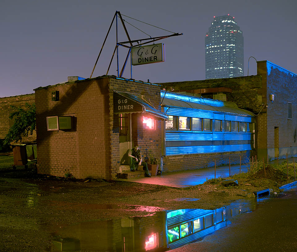
The old G & G Diner, in L.I.C., Queens.
The Creek’s growth did both fuel and parallel the city’s explosive development. For many, Newtown Creek, bogged with toxins, is the eyesore of a city and needs help. But it’s also loaded with forgotten importance – It might be the dark parallel to New York’s history and the ugly mirror of a city’s explosive growth, which, aside from the five Brooklyn/Queens neighborhoods that comprise it, cleverly shielded most residents from the uglier necessities of their economy.
It’s a place where many generations have toiled anonymously and where some famous names of industry left their mark – Bliss, Nichols, Pratt and Rockefeller.
But mostly it’s a place where many thousands continue to work in a blue-collar fashion, and in today’s New York that’s rare.
Lately the Creek is seen as a possible natural habitat and recreation site. Ideas from the Newcomers, suburban in origin, or, just plain, “not from here”? Can’t locate those ideas anywhere but inside the mind of a Newtowner, who, after all, can see things anew or fresh with hidden potential. I think natives have always seen it as the bad water place. But historically it’s the Newtowners who eventually get their way. Thus the future of the Creek will continue to be, at the very least, interesting, as the jobs and environmental perspectives influence the future of the B/Q.
I’m not sure if anyone is now calling for the Creek’s complete restoration, but if it were on someone’s mind, then envision a large swamp in the middle of New York that would still be the backwater it was before 1600. Back then, it just wasn’t a nice place to live, so no one did. It took new residents, like the Colonists to see its potential, and later, industrialists and city politicians saw the same commercial potential and maybe a fast cheap way to handle monumental amounts of sewage. Traditionally the Creek only bent to commerce but, now, recreation and luxury living, are having their say.
Living around the Creek for a while now, I’ve been carrying around the living history of the Brooklyn/Queens border neighborhoods, passed to me, by now-dead friends, who got it from their parents and grandparents – people like the local historians who gathered at the now-defunct social club across the street from my home. The living/working history sort of fueled this whole B/Q thing and brought me into the wider history and geography of Newtown Creek, whose name, for many years I never felt comfortable with. After all, there was, until recently, never anything new about it. It always seemed worn and old, only functioning for pure work. Until I knew all its history.
Thousands of New Yorkers today, make ends meet there, hundreds of thousands, over the years did the same – never pretty, but workaday and functional.
Whether providing resources for hunter/gatherers, colonial farmers or manufacturers, it’s commerce that originally expanded these Creek Bottoms, and Newtown Creek was literally built.
William Nichols, founder of Nichols Chemical Company (later Phelps Dodge) once said rather famously, “Newtown Creek is an outrageously libeled sheet of water. It is not a creek, but a branch of the East River, in fact, an extension of New York harbor, and, an essential part of the great commercial emporium of the New World.” It pretty much still functions in that manner today, plus a few bike lanes…
Slowly, over 26 years, B/Q documents this zone that is always reworking itself and continues to offer blue-collar jobs, even in the luxury city. A place where people produce in succeeding waves of citizens going back to colonial, even ancient times. During these years, documenting the B/Q, the area has moved out of its heavy industry and Rust Belt roots into lighter manufacturing and warehousing. Many of the symbols of heavy industry have been demolished – the Maspeth Holders, Greenpoint Incinerator, Dodge Phelps, and the Kosciusko is slated for demolition in 2014. The pollution is now taken very seriously and slowly much of the visible stuff – abandoned autos, flotsam and garbage has been cleaned up. And the smells, particularly since the Newtown Sewage Plant was rebuilt, are, relatively speaking, pretty much gone.
If you’re new to the tristate look over the surprising revelation that there are waterways whose purpose is not recreation. Luxuriate in a wildly industrial place, filled with boats, trains, bridges, factories, storage tanks, cemeteries and a big sky.
Or just stay at home with this book. But check out it’s rich, dark history.
Remembering, amongst many things, that plenty of the anonymous laboring generations, often immigrant – the ones who fabricated the city’s infrastructure and buildings with their hands – remain embedded near their homes and neighborhoods in the B/Q. In places like the Calvary Cemeteries, if you stand before their graves, you’ll see their names, millions of them, and you’ll also see some of the best views of the Manhattan skyline and the city they built.