
I never walked, when i could run.
JERSEY RUN (1995-2006) is a trenchant large-scale and thorough frame on the industrial corridor of North Jersey centered along the New Jersey Turnpike. In that flat open expanse of mud called the Meadowlands, from the garbage hills of the upper Hackensack and the industrial valley of the Passaic, into Newark Bay and down the Arthur Kill and into Raritan Bay, lies an urban carpet – the port cities of Newark, Elizabeth, Jersey City and Bayonne and the river and kill towns of Kearney, Secaucus, Carteret, Port Reading and Perth Amboy.
The infrastructure is determined by the distinct geography of the Meadowlands: the Hackensack River and its wetlands and swamps edging out the cities of Arlington, Kearney, Seacaucus, Jersey City and Newark. The Palisades, its ridge of trap rock separating the valley of the Hack from the same on the Hudson, is also where Union City, Weehawken and Jersey City Heights top out. There’s Newark Bay to the south where Jersey City, Newark, Elizabeth and Bayonne crowd around the great Port and bay, and below that, the industrial Kill towns of Perth Amboy, Carteret, Linden and Elizabeth that line the Arthur Kill.
The cities of the Meadowlands still provide an ideal location for industry. But don’t think ruins. It’s an old worn landscape, but it’s completely active and continually expanding. I saw a lot of sublime things, but rarely dead things. The Bergen Arches & Erie Cut and the Port Reading Coal Dumper probably fit that bill, but whatever abandonment exists, is always because of toxins.
The Meadowlands has its share of world-class sullage. Two superfund sites: Diamond Alkali, makers of agent orange (pcb, dioxin) on the Passaic in Newark and Standard Chlorine (naphthalene, etc.) on the Hackensack River in Kearney near the Portal Swing Bridge, are standouts. Many you can’t see like the long gone Coppers Coke Plant just downriver from Standard Chlorine and across from the fossil-fueled Hudson Generator. Others, capped over, are no man lands like the old PJP Dump and landfill site that stretches along the Hack from Three Bridges to The Skyway. Here the unsorted waste of the universe was piled high enough to practically make contact with Skyway itself. It was constantly burning above and below ground, fed by barrels of god-knows-what. In the seventies no one paid any mind to the perpetual flames and smoke down by the river, it was Jersey after all, and it was the Meadowlands. Today its remediation has progressed to capping and some light warehousing maybe and, of course, the parks.
People yap about the uses that landfills will be restored to, like golf courses on Landfill 1-E or even housing. Land in the dumps can sink up to fifty feet a year. Capping seals and little else, but that’s enough for some uses. They did build stadiums out there for teams from New York to play in, and there’s the Xanadu Shopping Mall for shopping fun, proven solutions from the Awesome Age of Reinvention. But that’s way in the north Meadowlands, and, as soon as you go below Snake Hill it’s pretty grim with industry and within the reach of ocean vessels. Environmentally, it’s a big-time bad land from here on down. And it used to be very bad.
Today it would never occur to anyone to dig deep pits and bury any old hazardous waste on the shores of, what is at this point, a huge river, let alone in the middle of cities. It was just 40 years ago the PJP landfill was perpetually ablaze, grilling the underbelly of the Skyway with poisonous smoke. The contamination includes the heavy metal chromium, phenols, various pesticides, and volatile organic chemicals (VOCs). The leachate from the landfill is also contaminated with VOCs, including benzene and chlorobenzene, and the heavy metal lead. The 87-acre PJP site is one of the many landfills that line the valley of the Hack from Ridgefield to Jersey City. In this case, the PJP actually lines the shores of the Hack like the Makala landfill just north in the same city. All the capped landfills along the Hack look like rolling green hills now, bellying what’s underneath.
It’s still the ideal place for large-scale industry, even with any contamination below. The system of waterways that all end up in the Atlantic Ocean, combined with abundant rail, means you’ve got the cheapest way to move bulk cargoes, including people. It’s a place people come to work, pass through, but not reside. I would say flooding is the biggest of many reasons to build homes elsewhere. The only town within the Meadowlands itself is Seacaucus. But the cities of north Jersey do crowd the edges.
Structures set in these difficult wet muddy sunken landscapes and waterways or those bored through the rock formations of Jersey Heights, photographically, became totems. That is to say, centers of work and contention. Struggling like a pig in the Meadows’ muck was required to secure shots of both movement and stillness in an area often hostile, whether in its natural state or in the man-made fabrications that lie upon it, over it and under it.
There were the Tunnels – The Bergen Arches and Erie Cut and the Bergen Tunnels, as well as, the North River Tunnels that allow direct access to Penn Station in Manhattan for all Amtrak and NJ Transit trains from the Meadowlands and the west. The portals for these Tunnels are where the Meadowlands end at the Heights. They were cut and bored through the Palisades to reach the Hudson River or even go underneath it. In the case of the North Tunnels, it’s so active more tubes are to be built, while the Bergen Tunnels received a complete rehab in 2001. There’s been talk of a highway for Bergen Arches (what else could it be?) since it closed, but that plan matches the stillness and regress of the Cut itself.
The first Bergen Tunnel, which allows trains out of the Meadowlands, to go under Jersey Heights, through Bergen Hill and into Hoboken and the Hudson, was dug in 1876. Today, here at the Bergen Tunnels nine commuter rail lines from all over Jersey – west, south and north – sweep into the Meadows, cross the Hack over one of four movable bridges and are squeezed down through the West Interlocking into one of two portals, then a straight shot through the Palisades and the Heights into Hoboken.
Part of the lure of Jersey was the ability to be in nature with no human presence while still being in the heart of extreme population density. In the years I spent at the North Tunnels, aside from Amtrak police, I saw one person. Likewise at the Bergen Tunnels & Arches, just one person. Both were lunatics. I spent six years, mostly fall and winters, pulling shots out of this below ground world. These Tunnels were old, worn and sublime. Built as temples of transport, long neglected, they appeared a lost world, tucked into the cut diabase of the Palisades. But they were completely functional, and, like all tristate infrastructure, if it isn’t expanding, it needs to. The Erie Cut, now a jungle, with its hanging gardens clinging to the walls and trees reaching up in any area of exposed light, is the exception. All the other old passages through the Heights still explode with activity.
The Bergen Tunnels received a complete rehab in 2001 including landscaping and modern security. Leakage, the main problem, has been taken care of and no longer do ice stalactites dangle from the seeps during winter. (In fact, that very scene is what hooked me into the Tunnels, while driving by on Tonnelle Ave. in the winter, you could see the huge ice stalactites hanging at the portals of the north and south tubes.) The years of soot and debris have been blasted clean. In the tunnel you no longer see the exposed innards of the Palisades, chopped by hand, but a smooth concrete lining. Even the Tunnel facades have been restored along with the commemorative plaques above the portals.
(Before the Bergen Tunnels were rehabbed, if you came in on any of the nine commuter lines, you would traverse the dumps, landfills, swamps and marshes of the Meadowlands, cross the Hack on one of four a movable bridges, through more landfills and toxic waste sites, at the Hudson Generator, you would be fed through the West Interlocking tracks next to St. Peter’s Cemetery, where, if it was winter, open gas fires heat the tracks to keep the switches open, crossing under Route 1 & 9 (Tonnelle Ave.), you proceed across a bridge over the CSX freight line coming out of the Long Dock Tunnel, next to the great Erie Cut and just as your train reaches the other side of the bridge you are in the Bergen Tunnel, speeding in a straight shot to Hoboken. The walls of the tunnel are made up of hand carved exposed trap dikes with contacts for the pentagrams bolted to the ceiling.)
At the Bergen Tunnels 250 trains pass through Bergen Hill every day. And, if you needed completely steady shots in one-hour exposures, there couldn’t be a worse place to set the camera, inches from the trains, mostly at rush hours to grab movement. Here I found some of the most difficult film work I’ve encountered. My insistence on extremely slow film – Ektar 25, requiring average exposure times of one hour while holding to a standard of completely sharp and still pictures, even while recording luminous movement, insured I would have my work cut out for me down here.
In fact throughout JERSEY RUN, shooting the most complex and one of the oldest industrialized transportation corridors in America is itself a challenge, but getting it to hold still for an hour while set upon 267 feet of mud is worse. Vibration, movement and constant non-stop use, will be the wild cards. Vibration alone from passing trains in the busiest rail tunnels around required shooting through many seasons. In fact it took six years to secure all the Tunnel shots. Coincidently I took the last Tunnels shots in April of 2001. With 9/11 around the corner, the security, which should have been there in the first place (everything from the west squeezes into 3 sets of tunnels to make the Hudson), would make such an endeavor impossible.
Next to and below the Bergen Tunnels are the abandoned Bergen Arches and Erie Cut. An engineering marvel, that sent four train lines through the Palisades to the Hudson River and the Pavonia Station, is today a lost world of overgrown flora set in a man-made canyon cut into the blue trap rock of Bergen Hill. Here they didn’t bother with a tunnel, but dynamited a mile long, 60 foot deep 60 foot wide trench in solid rock. That rock is diabase intrusive dike in geologic terms, and trap rock in mining and industrial terms, which is what the crushed rock of the Cut, was used for. One hundred years ago the rock walls were bare, freshly gouged, as was, all of the Cut, but even today the Palisade’s innards lie exposed and occasionally lit by daylight It’s mostly now a sunken arboretum, with one worn rail line left of four, and a path running down the middle. The other rails were pulled out years ago. The last Pavonia bound passenger train went through in 1959. But there is another tunnel that is still operational down here.
The Long Dock Tunnel (Erie) Tunnel lies next to and at the same level as the Arches and Cut. (Above the Long Dock is State Highway 139. At its west portal, the Pulaski Skyway ends and merges with 139 at a point directly above the Cut. State Road 139 also sits below street level and is called the “covered roadway” and it’s nothing but a direct underground highway into the Holland Tunnels. Although not in the Meadowlands, the Holland is another example of nine lanes narrowing into two on account of the geography of the Palisades and Hudson River.) The Long Dock is exclusively a freight tunnel allowing freight from the east and south access through the Palisades and into the Caxton Yards, which spread, for miles upon entering the flat meadowland.
The highways, streets, even buildings above in Jersey City, bridge over the Cut in all configurations and directions giving form to the arches and small tunnels down in the Cut itself.
Abandoned in place for 53 years now, nights in the Cut would be free of constant vigilance for security, electrocution or, as they say, being run over by a train. But the Cut had one uncertainty for shooting, as it happened to be home to one truly world-class crack head and Lost One. He would start fires at 3:00 am (he should be sleeping), even in the small tunnel where he was living inside a crack in the wall, to deter me. Occasionally in the pitch darkness of a tunnel I was shooting, doing long exposures, you could see him entering the tunnel as a silhouette about 500 feet away. He would eventually pass by me in the pure blackness, within inches. From his headphones I could clearly hear “Highway To Hell” blasting and fading as he walked out the other end. No doubt living after dusk strengthens night vision rods, as I never saw this one with any sort of light.
Other than that, it was a real JERSEY RUN, strangely peaceful, yet in the very heart of Jersey City. Above, sky, all else flush with flora, four legged critters and birds (and one two-legged idiot). In the crumbling industrial splendor, it was easy to forget that, not just the bridges, tunnels and rail lines were built, but the entire topography.
The Cut, like the Tunnels, has only two ways to enter or leave. A real trap, heightening the things required on a JERSEY RUN: if need be, you gotta stand straight, if active you gotta know how to lay low, if spotted you gotta know where and how to run. Finally and philosophically, locations such as the Tunnels were lessons in fate and impossibility. Played out in a sublime industrial wonderland of things, one could bottom out there. It eventually occurred to me, that, in willfully burning the bridges that land nowhere, and, after all, should be burned, I had, inadvertently, found a new way to go across, and not be seen. I went under.
And I tried for invisibility for obvious and good reasons. For that time period, I belonged there.
Security was always the big question – my own safety and avoidance of the official security of hired guards, dogs, police and, what later became to be, the domestic anti-terrorist forces. After 9/11 a man continually photographing every bit of infrastructure, much of which heads into lower Manhattan, in an extremely brazen fashion at night, had to be crazy. In my case it was just a bit of bad timing since I had already been there for six years. Anyone else I met at 3:00 in the morning inside these locations, I guarantee, was crazy as hell. I soldiered on, post 9/11, as they say, just like our troops. And speaking of crazy, a portion of the reason why I went out here in the first place was the craziness of New York becoming what it’s become.
As always the night was an ally. Knowledge of the lay of the land combined with superior night vision mostly saved my ass, and eventually the shot. Seeing things in the dark may be difficult, of course, but not for the camera, which, if I had the will, could turn the landscape night-for-day. I did see first-hand the night vision capabilities that can be activated by working the night.
After safety and seeing in the dark, there was the environment. Places like Snake Hill, Three Bridges, the Hudson Generator, Landfill 1-E, and the NJTP are structures set in profuse nature, and the swamps, marshes, mud flats and rivers that are completely tidal in nature. The tides became an important wildcard, complicating access and timing for the picture, but with results worth the effort.
The Port Reading Coal Dumper in the southern part of the Meadowlands became another totem and center of trial and error. When set up on the half ruined and burned trestle that stuck out into Arthur Kill across from Fresh Kills on only full moon nights in the winter, I would lug fifty lb. bags of sand ballast up there to steady the camera for its 90 minute exposures, at slack tide to minimize the imperceptible movement of the entire collapsing structure by the currents. Even with this, it required four years of diligence. Only one shot captured the structure sitting still for the required sixty minutes, in some convergence of water, wind and who knows what.
In Jersey I stuck to it and could declare the work, done (according to the list of shots I had to get by virtue of owing a minimum to my subject) by 2003. Although I still continue to run to Jersey for my industrial action, too often lately I’ve been running through it, which, after all, is what we’re supposed to do in the first place.
But I plan to always hit Jersey. Because there’s so much, industry that is. It’s also why I don’t grieve the loss so much of the blue collar work that left Brooklyn for overseas, a significant portion went to Jersey. I do grieve lost Brooklyn and Manhattan, whose gentrified origins in 1995 put me on the JERSEY RUN in the first place.
North Jersey is dominated by industry of all kind, particularly chemicals, power generation, garbage dumps, landfills, toxic waste sites and prisons, but here, too, is a transportation network of movable bridges, tunnels, highways, flight paths, runways, sea-lanes and rail lines that support every form of transportation. And it’s a place of power and radio transmission, pipelines and antennae. In the air, under ground, on water, and land, manufactured products, food, commodities, waste and people are moved, stored, or shipped.
Jersey is about movement.
That means I shot, along with the industry, much infrastructure. Discovering along the way, the marvel of connections that comprise the portal to New York, Jersey and the Northeast. The transportation and transmission structures, particularly at night are the foundation of JERSEY RUN. It’s also why light, timing and movement are central to this work.
The shots of the flight paths in an out of Newark Airport exemplify these matters. In the beginning I would constantly have to cover the lens to avoid the lights from aircraft streaking the negative. The Meadowlands don’t just make the perfect path for roads and rails, but flights as well. There’s always as much action in the sky as on land, as aircraft descend and ascend in opposite directions (depending on wind) over the desolate, dark swath of swamps, and waterways where, if there is human activity, it’s transportation or industry. Sometimes with long exposures of landscapes, dealing with this constant air traffic, the lens would be covered for more time than the actual exposure.
Eventually going more with the flow, a seven-year run of shooting flight paths at night began. At night, out in the Meadows, the desolate t.e.u. yards and landfills were ideally suited for this pursuit, which required a big sky at night and serious darkness in the middle of incredible urban sprawl. Ubiquitous water would often help reflect that same sky and its light paths on to the tidal mud flats of Sawmill Creek, Kearney Marsh and the Hack on the Kearney side by the Generator.
The structure one would use most often to get to many locations in the Meadows is the most overlooked. Yet the Turnpike is the single biggest feat of engineering in the area, completed in 1951, the entire system cost just 250 million dollars, and is the fundamental link for all the towns and cities of the Meadows, not to mention all Jersey. The recurrent Jersey Turnpike provides the most impressive views of the flat terrain, as does the Pulaski Skyway.
I found equally impressive views underneath both the Turnpike and the Skyway since so much of this system is elevated above the North Jersey swamps and rivers. At certain places, particularly the Eastern Spur as it vaults the Hack next to Snake Hill, I felt the need to shoot the location 360 degrees, from all viewpoints, each time reaching for a convergence that could occur on certain notable nights of stillness, slack tide and proper atmospheric conditions. This area got continual attention in all seasons and times of day and night, until it was done. After all it was one of the Jersey power spots.
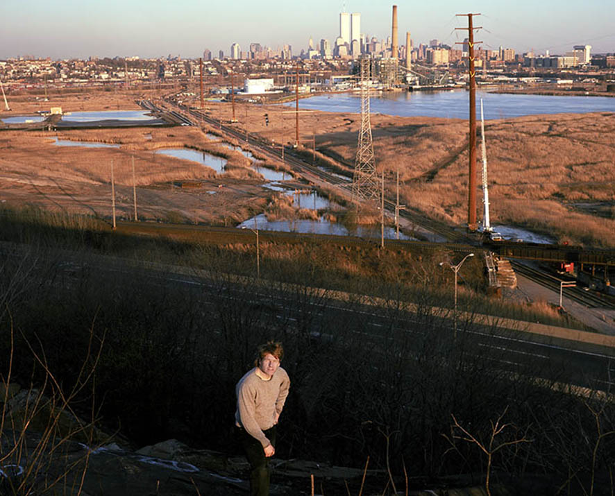
On Snake Hill at sunset – In the background – Hackensack River, Melinka Dump, Hudson Generator, Jersey City & Downtown Manhattan, and Amtrak & New Jersey Transit rail lines lie at the base of the hill.
The tracks just below, paralel to the NJTP, lead to the North River Tunnels and Manhattan, the rail lines heading towards downtown Manhattan is New Jersey transit heading to the West Interlock, where it will merge with all the rail lines from a 180 degree sweep of the west, eventually being squeezed into the Bergen Tunnels in the Palisades.
It’s not all swamps and rivers. Fifteen lanes of the NJTP cross over the Oak Island Rail Yards just south of the airport. Before it gets to this point in Newark, the eastern and western spurs of the turnpike merge over the swamps then rise together to vault the Passaic River, then go under the Pulaski Skyway in Newark, and passing the length of the north/south runways at Newark Airport they vault over the Oak Island Yards.
The familiar sublime things one sees while watching the introduction to THE SOPRANOS or moving through Jersey by plane, train, boat or auto, is where I holed up. This is a land of giants, but the land, too is noteworthy. It’s a pristine wild swampland of tidal streams and rivers, mud flats, and remnant forests. It’s also a landscape of leachates and toxins that ooze in vile springs to the surface, while an infinite variety of solid wastes randomly stray up from beneath the “ground.” The green valley of the Hack is composed of garbage hills and Newark Bay is nothing but a ring of industry. This urban geography is cast in names like Snake Hill, Point-No-Point, Kearney Swamp, Kingsland Swamp and Bergen Neck. It’s so inhospitable that only one town lies entirely in it, Seacaucus, which originated as pig farms.
Take Snake Hill, officially Laurel Hill, it’s the leading landmark in the Meadows. A huge diabase intrusion, this outcrop’s history includes prison, asylum, rock quarry, dump and cemetery for the poor and lost. Today, of course, it’s about half park area. There is a commanding view of the entire north Meadowlands: its swamps and landfills, Newark, the Jersey Heights and Manhattan skyline. An unparalleled perch, it and its views required extensive 360 degree shooting. With this much photographic attention, it’s no wonder such spots became profane deities, whose permission to leave and not return, meant getting the shot.
Over this collision of industry and nature is a true Big Sky haunted by birds of all kind. Add the ceaseless sound of transportation, the rich smell of landfills, chemical plants, decayed organics in the mud flats at low tide, air filled with particulates, bugs, emissions of all kind, and you’ve got a singular topography. It’s the natural world seeped in vile commerce of all sorts, yet somehow the nature never gets lost. And don’t forget the landscape is hostile. Often still, often loud, it’s always been uninhabitable for folks, for many good reasons, mostly centering on some discomfort: being poisoned, flooded, bit or buried come to mind. It’s a no good land. It’s for the birds, if you will.
Aside from nature, for better and worse, the Meadowlands of North Jersey is defined by industry. The pictures get this, while being mindful of light, movement, calm, stillness, and the beauty of utility. Mixing shots of monumental stillness and unceasing movement, usually at night, JERSEY RUN utilizes extreme time exposures (most shots average one hour in exposure). This is possible because I used very low speed film in the very low light in the most forgotten zones of the most urbanized sections of the state. Ceaseless vibration and security were the challenge in all seasons and all times of day and night. We’ve all heard of day-for-night photography in cinema. This was often night-for-day.
It was labor. The landscape simply dominates. On a good day you’re an ant, on a bad day you’re crushed. Ceaseless vibration, endless water and mud permeate all things. That Meadowlands’ mud is 267 feet thick, almost as thick as the mosquitoes.
It’s a big job similar to filling a large deep trench with dirt, by hand. Big enough that I still run to the Meadows and always will. There’s always a lot going on – the Witt Pen Bridge in the Triples is being replaced, Standard Chlorine is basically cleaned up, security is toughened and places like the Hudson Generator and the Tunnels are locked down, the neighborhood, Charlotte Circle in Jersey City has been taken out for, of course, more infrastructure – a complete redoing of where State Road 1 & 9, the Pulaski Skyway, State Route 7, State Route 139, NJ Transit and the CSX freight lines come together. It is finally being untangled and updated, its noir underbelly gone forever, except in JERSEY RUN.
During a tour of duty in which my EZ Pass bill alone equaled my film costs, shooting Jersey, mostly at night, was my job. When I say that the New Jersey Turnpike is the single most important engineered structure in the state, I mean it. JESEY RUN is a healthy combination of power-driving, going into locations loaded with gear, then doing what was necessary when I got there to secure the shot. Too often that could amount to perhaps a multi-year commitment to land, weather and timing for any given location.
Most failures were do to vibration or structural movement during typical one-hour exposures. Bridges on February nights had the least traffic, the least movement. Once in, I would plant a camera, stand ground, and if my timing was right, the Meadows might give up a shot. There was not a lot of the waiting one might expect when trying to get light, tides and action to come together properly for the shot. I had a lot of locations that were constantly juggled to fit conditions and times, and I knew how to get there quickly in a place known for monumental traffic tie-ups. Some nature, but all industry, and, particularly, transportation are on reliable timetables and that was a great aid. Atmospheric conditions and safety were not always predictable.
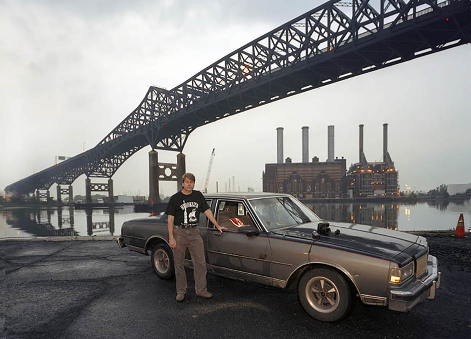
On Duncan Ave. in Jersey City where it deadends at the Hackensackk River, underneath the Pulaski Skyway and across the river from the Kearney Generator, TwoShoes, poses with his tools – Mamiya 7 with 43mm attached, light meter and Chevy Caprice. These Chevies provided good size for ample storage of equipment, and ability to turf ride, and take a beating off-road, as well as, cruise the phenomonal Meadowlands infrastructure at highest speeds allowable to collect as much data as possible.
Most of Jersey Run was shot before I had a computer. Mapping, weather tracking, traffic alerts and GPS, has made it so much easier now. The AM radio traffic alerts in my Chevy and the roof of my Brooklyn home to scout the weather to the west, were as technical as I got. And I used only film, the slowest made. Technically speaking I would also like to acknowledge my automobiles, the most important tool in aiding the shot. Those used in Jersey were the 1985 Chevy Caprice, the 1987 Chevy Caprice and finally the 2001 Chevy Impala. Ruggedness, an abundance of cheap used parts and large load capacity, combined with the then ultra cheap Jersey gas, made these rigs unstoppable. And if you were on a night run, the lack of traffic made the abundant tangle of highways a marvel.
The results of experience: driving skills, knowledge of the lay of the land or timing, is all just prepping for the wild card which, if delivered, could save the Jersey night.
Then we can be real specific about significant engineering sites like the Pulaski Skyway and the Bergen Arches, or, less known but legendary spots like Allied Junction, the Triples, West Interlock, and even the more prosaic geography of Landfill 1-E or the many t.e.u. yards.
These spots always had colorful names, and histories to match, and now they have pictures.
Jersey Run is a certified Going Under project.